You are here: Home > Network List > CI - Caltech Regional Seismic Network Stations List
> Station DEC Green Verdugo Microwave Site, Sunland, CA, USA > Earthquake Result Viewer
DEC Green Verdugo Microwave Site, Sunland, CA, USA - Earthquake Result Viewer
| Earthquake location: |
Andreanof Islands, Aleutian Is. |
| Earthquake latitude/longitude: |
51.9/-179.2 |
| Earthquake time(UTC): |
2008/04/16 (107) 05:54:19 GMT |
| Earthquake Depth: |
13 km |
| Earthquake Magnitude: |
6.1 MB, 6.5 MS, 6.6 MW, 6.6 MW |
| Earthquake Catalog/Contributor: |
WHDF/NEIC |
|
| Network: |
CI Caltech Regional Seismic Network |
| Station: |
DEC Green Verdugo Microwave Site, Sunland, CA, USA |
| Lat/Lon: |
34.25 N/118.33 W |
| Elevation: |
519 m |
|
| Distance: |
46.4 deg |
| Az: |
87.582 deg |
| Baz: |
311.606 deg |
| Ray Param: |
0.0706736 |
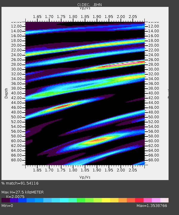
| Estimated Moho Depth: |
27.5 km |
| Estimated Crust Vp/Vs: |
2.01 |
| Assumed Crust Vp: |
6.1 km/s |
| Estimated Crust Vs: |
3.039 km/s |
| Estimated Crust Poisson's Ratio: |
0.33 |
|
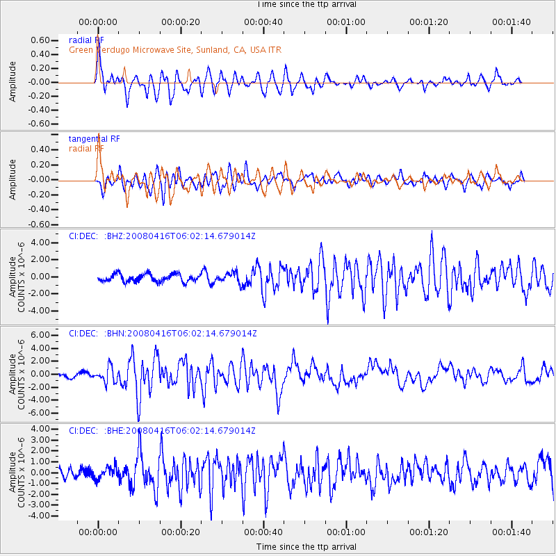
| Radial Match: |
91.54116 % |
| Radial Bump: |
400 |
| Transverse Match: |
76.23575 % |
| Transverse Bump: |
400 |
| SOD ConfigId: |
2504 |
| Insert Time: |
2010-02-26 00:16:30.486 +0000 |
| GWidth: |
2.5 |
| Max Bumps: |
400 |
| Tol: |
0.001 |
|
Signal To Noise
| Channel | StoN | STA | LTA |
| CI:DEC: :BHN:20080416T06:02:14.679014Z | 2.805322 | 1.1791045E-6 | 4.2030987E-7 |
| CI:DEC: :BHE:20080416T06:02:14.679014Z | 0.84584486 | 5.520932E-7 | 6.5271206E-7 |
| CI:DEC: :BHZ:20080416T06:02:14.679014Z | 1.4421552 | 6.4179005E-7 | 4.4502144E-7 |
| Arrivals |
| Ps | 4.8 SECOND |
| PpPs | 13 SECOND |
| PsPs/PpSs | 18 SECOND |


