You are here: Home > Network List > TA - USArray Transportable Network (new EarthScope stations) Stations List
> Station O03E Paynes Creek, CA, USA > Earthquake Result Viewer
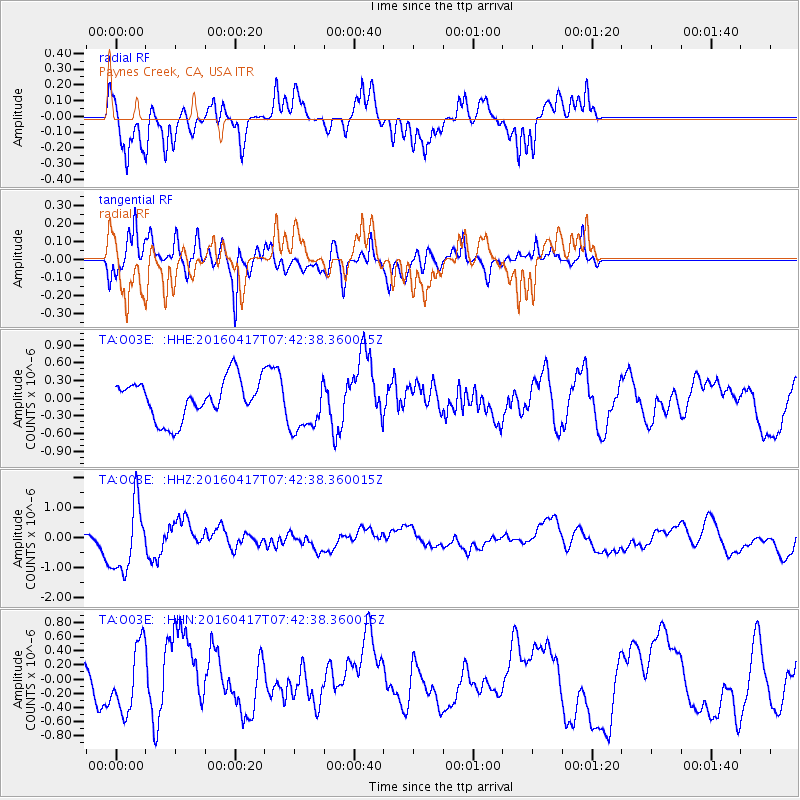
O03E Paynes Creek, CA, USA - Earthquake Result Viewer
*The percent match for this event was below the threshold and hence no stack was calculated.
| Earthquake location: |
Tonga Islands Region |
| Earthquake latitude/longitude: |
-23.6/-174.3 |
| Earthquake time(UTC): |
2016/04/17 (108) 07:31:03 GMT |
| Earthquake Depth: |
35 km |
| Earthquake Magnitude: |
5.8 MB |
| Earthquake Catalog/Contributor: |
NEIC PDE/NEIC COMCAT |
|
| Network: |
TA USArray Transportable Network (new EarthScope stations) |
| Station: |
O03E Paynes Creek, CA, USA |
| Lat/Lon: |
40.29 N/121.80 W |
| Elevation: |
967 m |
|
| Distance: |
80.2 deg |
| Az: |
38.026 deg |
| Baz: |
227.631 deg |
| Ray Param: |
$rayparam |
*The percent match for this event was below the threshold and hence was not used in the summary stack. |
|
| Radial Match: |
74.20079 % |
| Radial Bump: |
381 |
| Transverse Match: |
59.947227 % |
| Transverse Bump: |
373 |
| SOD ConfigId: |
7422571 |
| Insert Time: |
2019-04-22 08:38:10.119 +0000 |
| GWidth: |
2.5 |
| Max Bumps: |
400 |
| Tol: |
0.001 |
|
Signal To Noise
| Channel | StoN | STA | LTA |
| TA:O03E: :HHZ:20160417T07:42:38.360015Z | 3.7994728 | 1.1186979E-6 | 2.9443504E-7 |
| TA:O03E: :HHN:20160417T07:42:38.360015Z | 1.4052838 | 4.6180773E-7 | 3.286224E-7 |
| TA:O03E: :HHE:20160417T07:42:38.360015Z | 1.1869541 | 4.1476727E-7 | 3.4943835E-7 |
| Arrivals |
| Ps | |
| PpPs | |
| PsPs/PpSs | |


