You are here: Home > Network List > US - United States National Seismic Network Stations List
> Station NEW Newport, Washington, USA > Earthquake Result Viewer
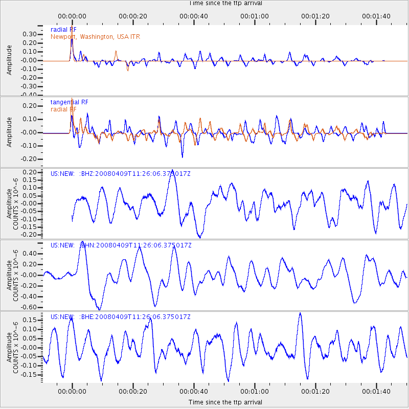
NEW Newport, Washington, USA - Earthquake Result Viewer
*The percent match for this event was below the threshold and hence no stack was calculated.
| Earthquake location: |
Loyalty Islands |
| Earthquake latitude/longitude: |
-20.2/168.9 |
| Earthquake time(UTC): |
2008/04/09 (100) 11:13:17 GMT |
| Earthquake Depth: |
13 km |
| Earthquake Magnitude: |
5.6 MB, 6.3 MS, 6.4 MW, 6.3 MW |
| Earthquake Catalog/Contributor: |
WHDF/NEIC |
|
| Network: |
US United States National Seismic Network |
| Station: |
NEW Newport, Washington, USA |
| Lat/Lon: |
48.26 N/117.12 W |
| Elevation: |
760 m |
|
| Distance: |
94.7 deg |
| Az: |
40.132 deg |
| Baz: |
244.979 deg |
| Ray Param: |
$rayparam |
*The percent match for this event was below the threshold and hence was not used in the summary stack. |
|
| Radial Match: |
65.411026 % |
| Radial Bump: |
358 |
| Transverse Match: |
67.49547 % |
| Transverse Bump: |
400 |
| SOD ConfigId: |
2504 |
| Insert Time: |
2010-03-05 01:46:07.377 +0000 |
| GWidth: |
2.5 |
| Max Bumps: |
400 |
| Tol: |
0.001 |
|
Signal To Noise
| Channel | StoN | STA | LTA |
| US:NEW: :BHN:20080409T11:26:06.375017Z | 4.2785974 | 3.676901E-7 | 8.593707E-8 |
| US:NEW: :BHE:20080409T11:26:06.375017Z | 1.2232873 | 8.634093E-8 | 7.058107E-8 |
| US:NEW: :BHZ:20080409T11:26:06.375017Z | 2.1229281 | 1.2947368E-7 | 6.098825E-8 |
| Arrivals |
| Ps | |
| PpPs | |
| PsPs/PpSs | |


