You are here: Home > Network List > TA - USArray Transportable Network (new EarthScope stations) Stations List
> Station R11A Troy Canyon, Currant, NV, USA > Earthquake Result Viewer
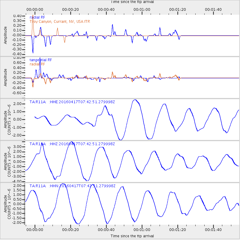
R11A Troy Canyon, Currant, NV, USA - Earthquake Result Viewer
*The percent match for this event was below the threshold and hence no stack was calculated.
| Earthquake location: |
Tonga Islands Region |
| Earthquake latitude/longitude: |
-23.6/-174.3 |
| Earthquake time(UTC): |
2016/04/17 (108) 07:31:03 GMT |
| Earthquake Depth: |
35 km |
| Earthquake Magnitude: |
5.8 MB |
| Earthquake Catalog/Contributor: |
NEIC PDE/NEIC COMCAT |
|
| Network: |
TA USArray Transportable Network (new EarthScope stations) |
| Station: |
R11A Troy Canyon, Currant, NV, USA |
| Lat/Lon: |
38.35 N/115.59 W |
| Elevation: |
1756 m |
|
| Distance: |
82.6 deg |
| Az: |
42.666 deg |
| Baz: |
232.251 deg |
| Ray Param: |
$rayparam |
*The percent match for this event was below the threshold and hence was not used in the summary stack. |
|
| Radial Match: |
73.56457 % |
| Radial Bump: |
400 |
| Transverse Match: |
97.61078 % |
| Transverse Bump: |
363 |
| SOD ConfigId: |
7422571 |
| Insert Time: |
2019-04-22 08:38:14.794 +0000 |
| GWidth: |
2.5 |
| Max Bumps: |
400 |
| Tol: |
0.001 |
|
Signal To Noise
| Channel | StoN | STA | LTA |
| TA:R11A: :HHZ:20160417T07:42:51.279998Z | 2.181872 | 2.3614032E-6 | 1.0822832E-6 |
| TA:R11A: :HHN:20160417T07:42:51.279998Z | 1.5327622 | 1.0152912E-6 | 6.623932E-7 |
| TA:R11A: :HHE:20160417T07:42:51.279998Z | 1.3993566 | 5.883784E-7 | 4.204635E-7 |
| Arrivals |
| Ps | |
| PpPs | |
| PsPs/PpSs | |


