You are here: Home > Network List > UW - Pacific Northwest Regional Seismic Network Stations List
> Station UMAT Pilot Rock, OR, USA > Earthquake Result Viewer
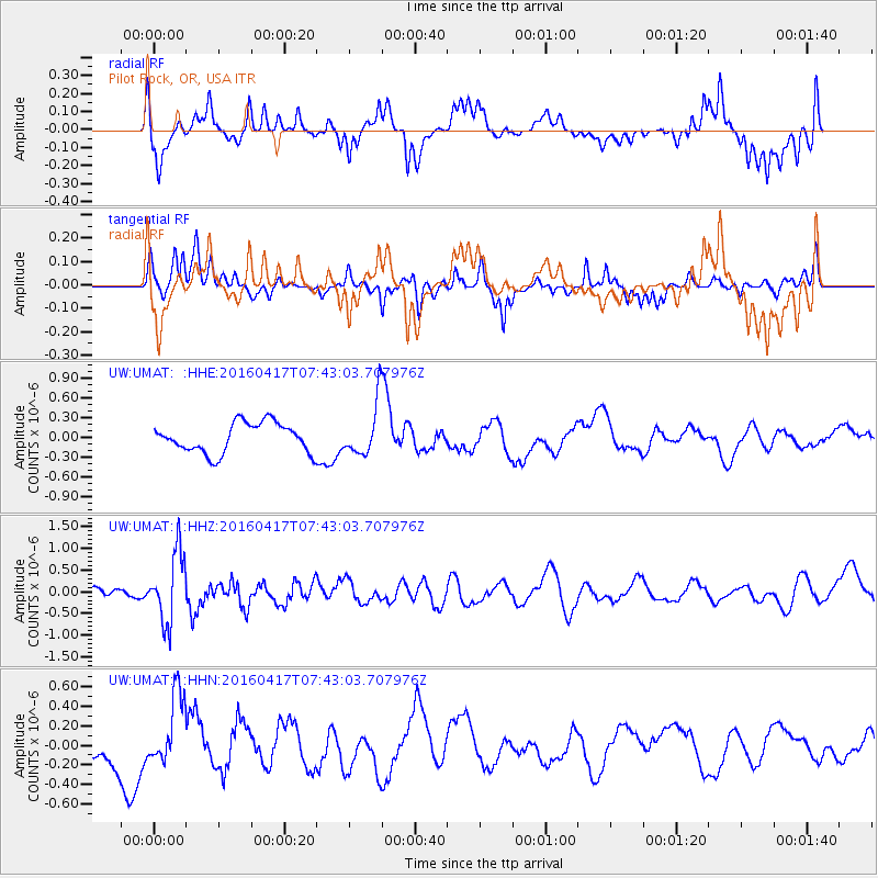
UMAT Pilot Rock, OR, USA - Earthquake Result Viewer
*The percent match for this event was below the threshold and hence no stack was calculated.
| Earthquake location: |
Tonga Islands Region |
| Earthquake latitude/longitude: |
-23.6/-174.3 |
| Earthquake time(UTC): |
2016/04/17 (108) 07:31:03 GMT |
| Earthquake Depth: |
35 km |
| Earthquake Magnitude: |
5.8 MB |
| Earthquake Catalog/Contributor: |
NEIC PDE/NEIC COMCAT |
|
| Network: |
UW Pacific Northwest Regional Seismic Network |
| Station: |
UMAT Pilot Rock, OR, USA |
| Lat/Lon: |
45.29 N/118.96 W |
| Elevation: |
1318 m |
|
| Distance: |
85.1 deg |
| Az: |
35.66 deg |
| Baz: |
229.253 deg |
| Ray Param: |
$rayparam |
*The percent match for this event was below the threshold and hence was not used in the summary stack. |
|
| Radial Match: |
72.64155 % |
| Radial Bump: |
400 |
| Transverse Match: |
54.960644 % |
| Transverse Bump: |
314 |
| SOD ConfigId: |
7422571 |
| Insert Time: |
2019-04-22 08:39:04.278 +0000 |
| GWidth: |
2.5 |
| Max Bumps: |
400 |
| Tol: |
0.001 |
|
Signal To Noise
| Channel | StoN | STA | LTA |
| UW:UMAT: :HHZ:20160417T07:43:03.707976Z | 4.1894774 | 7.9761975E-7 | 1.9038646E-7 |
| UW:UMAT: :HHN:20160417T07:43:03.707976Z | 1.9059328 | 3.66176E-7 | 1.921243E-7 |
| UW:UMAT: :HHE:20160417T07:43:03.707976Z | 2.307866 | 5.4864614E-7 | 2.3772877E-7 |
| Arrivals |
| Ps | |
| PpPs | |
| PsPs/PpSs | |


