You are here: Home > Network List > US - United States National Seismic Network Stations List
> Station MSO Missoula, Montana, USA > Earthquake Result Viewer
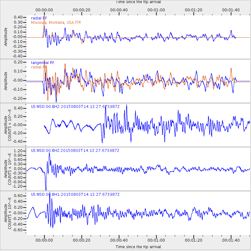
MSO Missoula, Montana, USA - Earthquake Result Viewer
*The percent match for this event was below the threshold and hence no stack was calculated.
| Earthquake location: |
Tonga Islands |
| Earthquake latitude/longitude: |
-16.5/-174.3 |
| Earthquake time(UTC): |
2015/08/03 (215) 14:01:51 GMT |
| Earthquake Depth: |
162 km |
| Earthquake Magnitude: |
5.7 MWB, 5.7 MWW |
| Earthquake Catalog/Contributor: |
NEIC PDE/NEIC COMCAT |
|
| Network: |
US United States National Seismic Network |
| Station: |
MSO Missoula, Montana, USA |
| Lat/Lon: |
46.83 N/113.94 W |
| Elevation: |
1264 m |
|
| Distance: |
83.1 deg |
| Az: |
36.97 deg |
| Baz: |
237.184 deg |
| Ray Param: |
$rayparam |
*The percent match for this event was below the threshold and hence was not used in the summary stack. |
|
| Radial Match: |
61.677727 % |
| Radial Bump: |
400 |
| Transverse Match: |
64.36016 % |
| Transverse Bump: |
400 |
| SOD ConfigId: |
1085051 |
| Insert Time: |
2015-08-17 14:42:25.907 +0000 |
| GWidth: |
2.5 |
| Max Bumps: |
400 |
| Tol: |
0.001 |
|
Signal To Noise
| Channel | StoN | STA | LTA |
| US:MSO:00:BHZ:20150803T14:13:27.673987Z | 7.7274847 | 5.6887376E-7 | 7.361694E-8 |
| US:MSO:00:BH1:20150803T14:13:27.673987Z | 3.1629744 | 2.8465328E-7 | 8.9995446E-8 |
| US:MSO:00:BH2:20150803T14:13:27.673987Z | 2.607269 | 1.9929708E-7 | 7.6439015E-8 |
| Arrivals |
| Ps | |
| PpPs | |
| PsPs/PpSs | |


