You are here: Home > Network List > US - United States National Seismic Network Stations List
> Station NEW Newport, Washington, USA > Earthquake Result Viewer
NEW Newport, Washington, USA - Earthquake Result Viewer
*The percent match for this event was below the threshold and hence no stack was calculated.
| Earthquake location: |
Tonga Islands |
| Earthquake latitude/longitude: |
-15.8/-173.5 |
| Earthquake time(UTC): |
2009/05/13 (133) 21:31:17 GMT |
| Earthquake Depth: |
85 km |
| Earthquake Magnitude: |
5.8 MW, 5.3 MB, 5.8 MW |
| Earthquake Catalog/Contributor: |
WHDF/NEIC |
|
| Network: |
US United States National Seismic Network |
| Station: |
NEW Newport, Washington, USA |
| Lat/Lon: |
48.26 N/117.12 W |
| Elevation: |
760 m |
|
| Distance: |
81.0 deg |
| Az: |
34.279 deg |
| Baz: |
234.258 deg |
| Ray Param: |
$rayparam |
*The percent match for this event was below the threshold and hence was not used in the summary stack. |
|
| Radial Match: |
43.130432 % |
| Radial Bump: |
400 |
| Transverse Match: |
52.366756 % |
| Transverse Bump: |
400 |
| SOD ConfigId: |
2760 |
| Insert Time: |
2010-03-05 01:46:37.705 +0000 |
| GWidth: |
2.5 |
| Max Bumps: |
400 |
| Tol: |
0.001 |
|
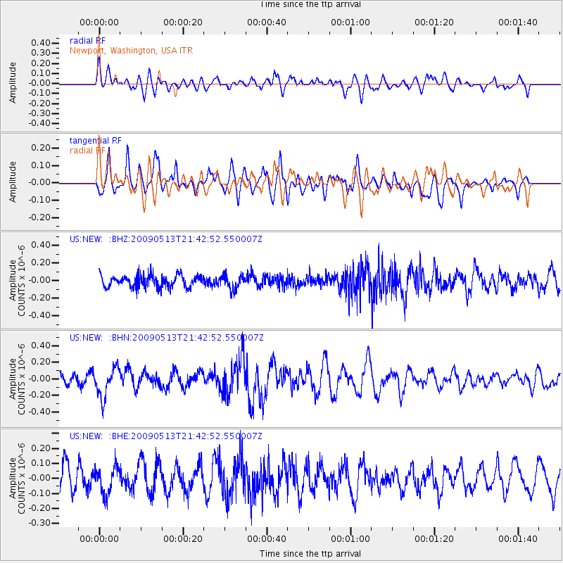
Signal To Noise
| Channel | StoN | STA | LTA |
| US:NEW: :BHN:20090513T21:42:52.550007Z | 2.733581 | 1.852071E-7 | 6.775255E-8 |
| US:NEW: :BHE:20090513T21:42:52.550007Z | 0.89767355 | 9.0237855E-8 | 1.0052413E-7 |
| US:NEW: :BHZ:20090513T21:42:52.550007Z | 1.2372622 | 8.37515E-8 | 6.769098E-8 |
| Arrivals |
| Ps | |
| PpPs | |
| PsPs/PpSs | |


