You are here: Home > Network List > CN - Canadian National Seismograph Network Stations List
> Station INK INUVIK, NT > Earthquake Result Viewer
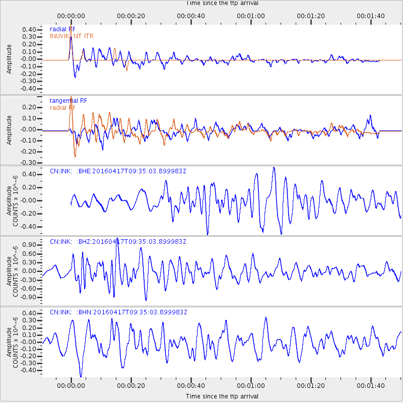
INK INUVIK, NT - Earthquake Result Viewer
*The percent match for this event was below the threshold and hence no stack was calculated.
| Earthquake location: |
Near Coast Of Ecuador |
| Earthquake latitude/longitude: |
-0.3/-80.7 |
| Earthquake time(UTC): |
2016/04/17 (108) 09:23:40 GMT |
| Earthquake Depth: |
10 km |
| Earthquake Magnitude: |
5.5 MB |
| Earthquake Catalog/Contributor: |
NEIC PDE/NEIC COMCAT |
|
| Network: |
CN Canadian National Seismograph Network |
| Station: |
INK INUVIK, NT |
| Lat/Lon: |
68.31 N/133.53 W |
| Elevation: |
44 m |
|
| Distance: |
77.3 deg |
| Az: |
342.322 deg |
| Baz: |
125.239 deg |
| Ray Param: |
$rayparam |
*The percent match for this event was below the threshold and hence was not used in the summary stack. |
|
| Radial Match: |
71.82134 % |
| Radial Bump: |
400 |
| Transverse Match: |
65.26081 % |
| Transverse Bump: |
400 |
| SOD ConfigId: |
7422571 |
| Insert Time: |
2019-04-22 08:44:16.366 +0000 |
| GWidth: |
2.5 |
| Max Bumps: |
400 |
| Tol: |
0.001 |
|
Signal To Noise
| Channel | StoN | STA | LTA |
| CN:INK: :BHZ:20160417T09:35:03.899983Z | 2.2765596 | 3.732448E-7 | 1.6395126E-7 |
| CN:INK: :BHN:20160417T09:35:03.899983Z | 2.5268974 | 2.5309168E-7 | 1.00159056E-7 |
| CN:INK: :BHE:20160417T09:35:03.899983Z | 1.9560386 | 1.6238333E-7 | 8.3016424E-8 |
| Arrivals |
| Ps | |
| PpPs | |
| PsPs/PpSs | |


