You are here: Home > Network List > US - United States National Seismic Network Stations List
> Station NEW Newport, Washington, USA > Earthquake Result Viewer
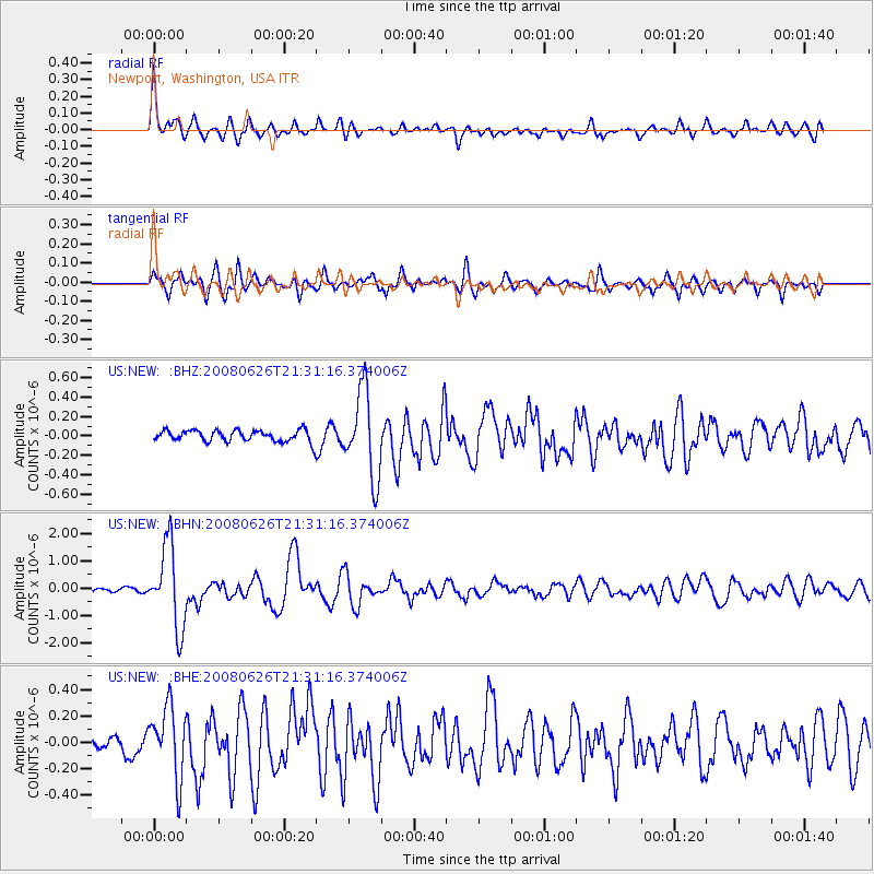
NEW Newport, Washington, USA - Earthquake Result Viewer
*The percent match for this event was below the threshold and hence no stack was calculated.
| Earthquake location: |
Tonga Islands |
| Earthquake latitude/longitude: |
-20.8/-173.3 |
| Earthquake time(UTC): |
2008/06/26 (178) 21:19:15 GMT |
| Earthquake Depth: |
38 km |
| Earthquake Magnitude: |
6.0 MB, 5.8 MS, 6.2 MW, 6.1 MW |
| Earthquake Catalog/Contributor: |
WHDF/NEIC |
|
| Network: |
US United States National Seismic Network |
| Station: |
NEW Newport, Washington, USA |
| Lat/Lon: |
48.26 N/117.12 W |
| Elevation: |
760 m |
|
| Distance: |
85.1 deg |
| Az: |
33.879 deg |
| Baz: |
231.324 deg |
| Ray Param: |
$rayparam |
*The percent match for this event was below the threshold and hence was not used in the summary stack. |
|
| Radial Match: |
76.146614 % |
| Radial Bump: |
400 |
| Transverse Match: |
76.736 % |
| Transverse Bump: |
400 |
| SOD ConfigId: |
2504 |
| Insert Time: |
2010-03-05 01:47:03.229 +0000 |
| GWidth: |
2.5 |
| Max Bumps: |
400 |
| Tol: |
0.001 |
|
Signal To Noise
| Channel | StoN | STA | LTA |
| US:NEW: :BHN:20080626T21:31:16.374006Z | 29.774956 | 1.4988241E-6 | 5.0338414E-8 |
| US:NEW: :BHE:20080626T21:31:16.374006Z | 3.5037003 | 2.6348133E-7 | 7.520088E-8 |
| US:NEW: :BHZ:20080626T21:31:16.374006Z | 7.422004 | 4.412232E-7 | 5.9447984E-8 |
| Arrivals |
| Ps | |
| PpPs | |
| PsPs/PpSs | |


