You are here: Home > Network List > US - United States National Seismic Network Stations List
> Station NEW Newport, Washington, USA > Earthquake Result Viewer
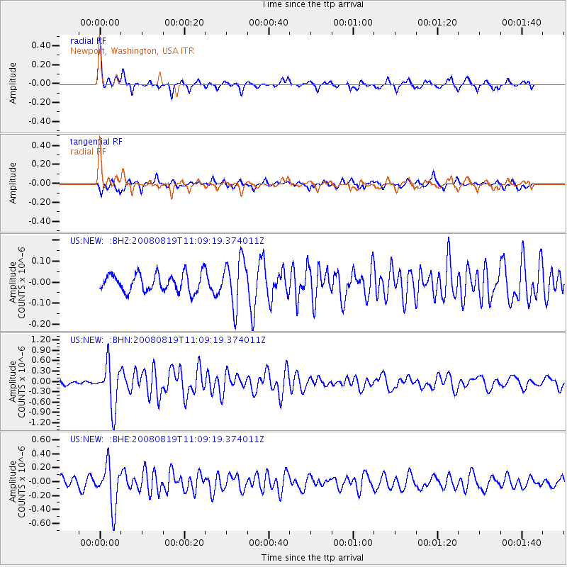
NEW Newport, Washington, USA - Earthquake Result Viewer
*The percent match for this event was below the threshold and hence no stack was calculated.
| Earthquake location: |
Easter Island Region |
| Earthquake latitude/longitude: |
-28.5/-112.8 |
| Earthquake time(UTC): |
2008/08/19 (232) 10:58:00 GMT |
| Earthquake Depth: |
9.0 km |
| Earthquake Magnitude: |
5.5 MB, 5.3 MS, 5.7 MW, 5.7 MW |
| Earthquake Catalog/Contributor: |
WHDF/NEIC |
|
| Network: |
US United States National Seismic Network |
| Station: |
NEW Newport, Washington, USA |
| Lat/Lon: |
48.26 N/117.12 W |
| Elevation: |
760 m |
|
| Distance: |
76.6 deg |
| Az: |
357.062 deg |
| Baz: |
176.131 deg |
| Ray Param: |
$rayparam |
*The percent match for this event was below the threshold and hence was not used in the summary stack. |
|
| Radial Match: |
79.43687 % |
| Radial Bump: |
394 |
| Transverse Match: |
76.55242 % |
| Transverse Bump: |
400 |
| SOD ConfigId: |
2504 |
| Insert Time: |
2010-03-05 01:47:17.003 +0000 |
| GWidth: |
2.5 |
| Max Bumps: |
400 |
| Tol: |
0.001 |
|
Signal To Noise
| Channel | StoN | STA | LTA |
| US:NEW: :BHN:20080819T11:09:19.374011Z | 9.575284 | 6.444203E-7 | 6.7300384E-8 |
| US:NEW: :BHE:20080819T11:09:19.374011Z | 3.7832837 | 3.087623E-7 | 8.161226E-8 |
| US:NEW: :BHZ:20080819T11:09:19.374011Z | 2.682877 | 1.1410981E-7 | 4.2532626E-8 |
| Arrivals |
| Ps | |
| PpPs | |
| PsPs/PpSs | |


