You are here: Home > Network List > US - United States National Seismic Network Stations List
> Station NEW Newport, Washington, USA > Earthquake Result Viewer
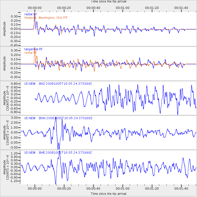
NEW Newport, Washington, USA - Earthquake Result Viewer
*The percent match for this event was below the threshold and hence no stack was calculated.
| Earthquake location: |
Tajikistan-Xinjiang Border Reg. |
| Earthquake latitude/longitude: |
39.5/73.8 |
| Earthquake time(UTC): |
2008/10/05 (279) 15:52:49 GMT |
| Earthquake Depth: |
27 km |
| Earthquake Magnitude: |
6.4 MB, 6.9 MS, 6.6 MW, 6.6 MW |
| Earthquake Catalog/Contributor: |
WHDF/NEIC |
|
| Network: |
US United States National Seismic Network |
| Station: |
NEW Newport, Washington, USA |
| Lat/Lon: |
48.26 N/117.12 W |
| Elevation: |
760 m |
|
| Distance: |
92.0 deg |
| Az: |
7.293 deg |
| Baz: |
351.552 deg |
| Ray Param: |
$rayparam |
*The percent match for this event was below the threshold and hence was not used in the summary stack. |
|
| Radial Match: |
74.47878 % |
| Radial Bump: |
400 |
| Transverse Match: |
60.526806 % |
| Transverse Bump: |
400 |
| SOD ConfigId: |
2556 |
| Insert Time: |
2010-03-05 01:47:17.683 +0000 |
| GWidth: |
2.5 |
| Max Bumps: |
400 |
| Tol: |
0.001 |
|
Signal To Noise
| Channel | StoN | STA | LTA |
| US:NEW: :BHN:20081005T16:05:24.373999Z | 0.68696153 | 1.7422619E-7 | 2.5361857E-7 |
| US:NEW: :BHE:20081005T16:05:24.373999Z | 0.7531498 | 1.5187241E-7 | 2.0164968E-7 |
| US:NEW: :BHZ:20081005T16:05:24.373999Z | 2.10361 | 2.9619562E-7 | 1.408035E-7 |
| Arrivals |
| Ps | |
| PpPs | |
| PsPs/PpSs | |


