You are here: Home > Network List > US - United States National Seismic Network Stations List
> Station NEW Newport, Washington, USA > Earthquake Result Viewer
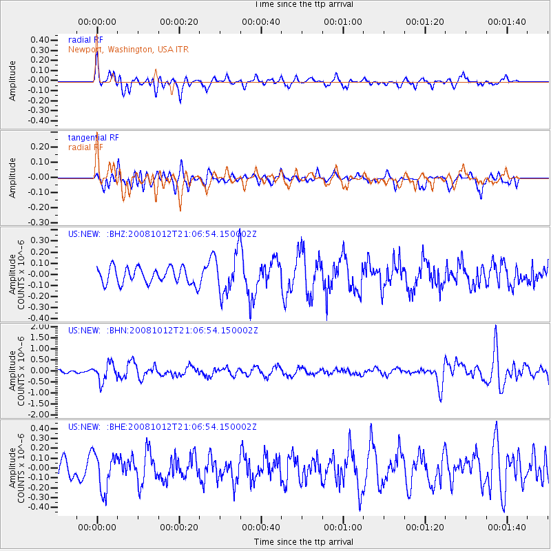
NEW Newport, Washington, USA - Earthquake Result Viewer
*The percent match for this event was below the threshold and hence no stack was calculated.
| Earthquake location: |
Southern Bolivia |
| Earthquake latitude/longitude: |
-20.1/-65.0 |
| Earthquake time(UTC): |
2008/10/12 (286) 20:55:41 GMT |
| Earthquake Depth: |
353 km |
| Earthquake Magnitude: |
6.0 MB, 6.2 MW, 6.2 MW |
| Earthquake Catalog/Contributor: |
WHDF/NEIC |
|
| Network: |
US United States National Seismic Network |
| Station: |
NEW Newport, Washington, USA |
| Lat/Lon: |
48.26 N/117.12 W |
| Elevation: |
760 m |
|
| Distance: |
82.5 deg |
| Az: |
327.847 deg |
| Baz: |
131.546 deg |
| Ray Param: |
$rayparam |
*The percent match for this event was below the threshold and hence was not used in the summary stack. |
|
| Radial Match: |
69.61688 % |
| Radial Bump: |
400 |
| Transverse Match: |
37.12639 % |
| Transverse Bump: |
400 |
| SOD ConfigId: |
2556 |
| Insert Time: |
2010-03-05 01:47:19.284 +0000 |
| GWidth: |
2.5 |
| Max Bumps: |
400 |
| Tol: |
0.001 |
|
Signal To Noise
| Channel | StoN | STA | LTA |
| US:NEW: :BHN:20081012T21:06:54.150002Z | 5.5401917 | 4.1522702E-7 | 7.494813E-8 |
| US:NEW: :BHE:20081012T21:06:54.150002Z | 1.6616261 | 1.8574012E-7 | 1.1178214E-7 |
| US:NEW: :BHZ:20081012T21:06:54.150002Z | 2.6315792 | 1.9055173E-7 | 7.240965E-8 |
| Arrivals |
| Ps | |
| PpPs | |
| PsPs/PpSs | |


