You are here: Home > Network List > TA - USArray Transportable Network (new EarthScope stations) Stations List
> Station A21K Barrow, AK, USA > Earthquake Result Viewer
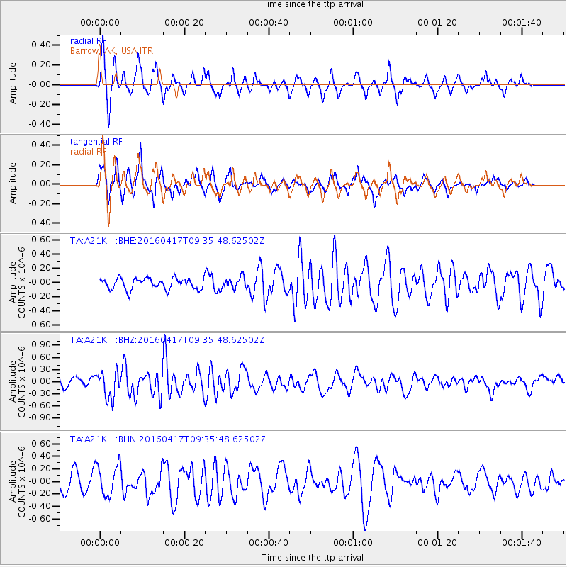
A21K Barrow, AK, USA - Earthquake Result Viewer
*The percent match for this event was below the threshold and hence no stack was calculated.
| Earthquake location: |
Near Coast Of Ecuador |
| Earthquake latitude/longitude: |
-0.3/-80.7 |
| Earthquake time(UTC): |
2016/04/17 (108) 09:23:40 GMT |
| Earthquake Depth: |
10 km |
| Earthquake Magnitude: |
5.5 MB |
| Earthquake Catalog/Contributor: |
NEIC PDE/NEIC COMCAT |
|
| Network: |
TA USArray Transportable Network (new EarthScope stations) |
| Station: |
A21K Barrow, AK, USA |
| Lat/Lon: |
71.32 N/156.62 W |
| Elevation: |
577 m |
|
| Distance: |
85.7 deg |
| Az: |
341.739 deg |
| Baz: |
103.453 deg |
| Ray Param: |
$rayparam |
*The percent match for this event was below the threshold and hence was not used in the summary stack. |
|
| Radial Match: |
76.77286 % |
| Radial Bump: |
366 |
| Transverse Match: |
75.451225 % |
| Transverse Bump: |
367 |
| SOD ConfigId: |
7422571 |
| Insert Time: |
2019-04-22 08:48:25.654 +0000 |
| GWidth: |
2.5 |
| Max Bumps: |
400 |
| Tol: |
0.001 |
|
Signal To Noise
| Channel | StoN | STA | LTA |
| TA:A21K: :BHZ:20160417T09:35:48.62502Z | 2.0020933 | 3.3027433E-7 | 1.6496452E-7 |
| TA:A21K: :BHN:20160417T09:35:48.62502Z | 1.6989707 | 2.4590008E-7 | 1.4473474E-7 |
| TA:A21K: :BHE:20160417T09:35:48.62502Z | 1.0347389 | 8.00462E-8 | 7.735884E-8 |
| Arrivals |
| Ps | |
| PpPs | |
| PsPs/PpSs | |


