You are here: Home > Network List > TA - USArray Transportable Network (new EarthScope stations) Stations List
> Station G05D Wamic, OR, USA > Earthquake Result Viewer
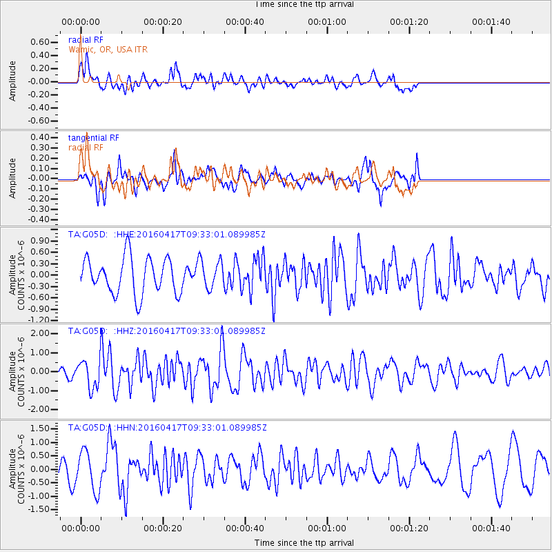
G05D Wamic, OR, USA - Earthquake Result Viewer
*The percent match for this event was below the threshold and hence no stack was calculated.
| Earthquake location: |
Near Coast Of Ecuador |
| Earthquake latitude/longitude: |
-0.3/-80.7 |
| Earthquake time(UTC): |
2016/04/17 (108) 09:23:40 GMT |
| Earthquake Depth: |
10 km |
| Earthquake Magnitude: |
5.5 MB |
| Earthquake Catalog/Contributor: |
NEIC PDE/NEIC COMCAT |
|
| Network: |
TA USArray Transportable Network (new EarthScope stations) |
| Station: |
G05D Wamic, OR, USA |
| Lat/Lon: |
45.24 N/121.32 W |
| Elevation: |
592 m |
|
| Distance: |
57.8 deg |
| Az: |
327.077 deg |
| Baz: |
129.708 deg |
| Ray Param: |
$rayparam |
*The percent match for this event was below the threshold and hence was not used in the summary stack. |
|
| Radial Match: |
61.370274 % |
| Radial Bump: |
400 |
| Transverse Match: |
57.857834 % |
| Transverse Bump: |
400 |
| SOD ConfigId: |
7422571 |
| Insert Time: |
2019-04-22 08:48:31.943 +0000 |
| GWidth: |
2.5 |
| Max Bumps: |
400 |
| Tol: |
0.001 |
|
Signal To Noise
| Channel | StoN | STA | LTA |
| TA:G05D: :HHZ:20160417T09:33:01.089985Z | 1.7854605 | 7.5067635E-7 | 4.204385E-7 |
| TA:G05D: :HHN:20160417T09:33:01.089985Z | 1.4805553 | 7.47564E-7 | 5.049214E-7 |
| TA:G05D: :HHE:20160417T09:33:01.089985Z | 0.77971184 | 3.7366203E-7 | 4.7923095E-7 |
| Arrivals |
| Ps | |
| PpPs | |
| PsPs/PpSs | |


