You are here: Home > Network List > TA - USArray Transportable Network (new EarthScope stations) Stations List
> Station J20K Nowitna River, AK, USA > Earthquake Result Viewer
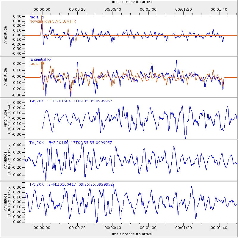
J20K Nowitna River, AK, USA - Earthquake Result Viewer
*The percent match for this event was below the threshold and hence no stack was calculated.
| Earthquake location: |
Near Coast Of Ecuador |
| Earthquake latitude/longitude: |
-0.3/-80.7 |
| Earthquake time(UTC): |
2016/04/17 (108) 09:23:40 GMT |
| Earthquake Depth: |
10 km |
| Earthquake Magnitude: |
5.5 MB |
| Earthquake Catalog/Contributor: |
NEIC PDE/NEIC COMCAT |
|
| Network: |
TA USArray Transportable Network (new EarthScope stations) |
| Station: |
J20K Nowitna River, AK, USA |
| Lat/Lon: |
64.18 N/154.15 W |
| Elevation: |
314 m |
|
| Distance: |
83.1 deg |
| Az: |
334.983 deg |
| Baz: |
105.082 deg |
| Ray Param: |
$rayparam |
*The percent match for this event was below the threshold and hence was not used in the summary stack. |
|
| Radial Match: |
60.068836 % |
| Radial Bump: |
400 |
| Transverse Match: |
63.201202 % |
| Transverse Bump: |
400 |
| SOD ConfigId: |
7422571 |
| Insert Time: |
2019-04-22 08:48:37.441 +0000 |
| GWidth: |
2.5 |
| Max Bumps: |
400 |
| Tol: |
0.001 |
|
Signal To Noise
| Channel | StoN | STA | LTA |
| TA:J20K: :BHZ:20160417T09:35:35.099995Z | 4.1611404 | 2.7458685E-7 | 6.598836E-8 |
| TA:J20K: :BHN:20160417T09:35:35.099995Z | 1.2074642 | 1.3333E-7 | 1.1042149E-7 |
| TA:J20K: :BHE:20160417T09:35:35.099995Z | 1.3305609 | 1.2491243E-7 | 9.3879535E-8 |
| Arrivals |
| Ps | |
| PpPs | |
| PsPs/PpSs | |


