You are here: Home > Network List > TA - USArray Transportable Network (new EarthScope stations) Stations List
> Station MSTX Muleshoe, TX, USA > Earthquake Result Viewer
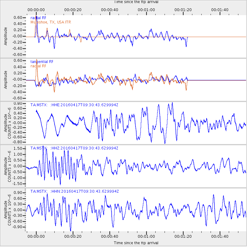
MSTX Muleshoe, TX, USA - Earthquake Result Viewer
*The percent match for this event was below the threshold and hence no stack was calculated.
| Earthquake location: |
Near Coast Of Ecuador |
| Earthquake latitude/longitude: |
-0.3/-80.7 |
| Earthquake time(UTC): |
2016/04/17 (108) 09:23:40 GMT |
| Earthquake Depth: |
10 km |
| Earthquake Magnitude: |
5.5 MB |
| Earthquake Catalog/Contributor: |
NEIC PDE/NEIC COMCAT |
|
| Network: |
TA USArray Transportable Network (new EarthScope stations) |
| Station: |
MSTX Muleshoe, TX, USA |
| Lat/Lon: |
33.97 N/102.77 W |
| Elevation: |
1167 m |
|
| Distance: |
39.8 deg |
| Az: |
330.85 deg |
| Baz: |
144.118 deg |
| Ray Param: |
$rayparam |
*The percent match for this event was below the threshold and hence was not used in the summary stack. |
|
| Radial Match: |
71.6603 % |
| Radial Bump: |
400 |
| Transverse Match: |
45.051598 % |
| Transverse Bump: |
400 |
| SOD ConfigId: |
7422571 |
| Insert Time: |
2019-04-22 08:48:47.559 +0000 |
| GWidth: |
2.5 |
| Max Bumps: |
400 |
| Tol: |
0.001 |
|
Signal To Noise
| Channel | StoN | STA | LTA |
| TA:MSTX: :HHZ:20160417T09:30:43.629994Z | 6.0080132 | 6.6147084E-7 | 1.1009811E-7 |
| TA:MSTX: :HHN:20160417T09:30:43.629994Z | 1.0209816 | 2.5479096E-7 | 2.4955492E-7 |
| TA:MSTX: :HHE:20160417T09:30:43.629994Z | 1.212467 | 3.1870567E-7 | 2.628572E-7 |
| Arrivals |
| Ps | |
| PpPs | |
| PsPs/PpSs | |


