You are here: Home > Network List > TA - USArray Transportable Network (new EarthScope stations) Stations List
> Station WHTX Lake Whitney, Meridian, TX, USA > Earthquake Result Viewer
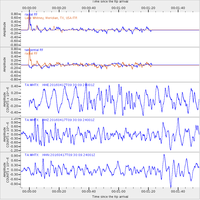
WHTX Lake Whitney, Meridian, TX, USA - Earthquake Result Viewer

| Earthquake location: |
Near Coast Of Ecuador |
| Earthquake latitude/longitude: |
-0.3/-80.7 |
| Earthquake time(UTC): |
2016/04/17 (108) 09:23:40 GMT |
| Earthquake Depth: |
10 km |
| Earthquake Magnitude: |
5.5 MB |
| Earthquake Catalog/Contributor: |
NEIC PDE/NEIC COMCAT |
|
| Network: |
TA USArray Transportable Network (new EarthScope stations) |
| Station: |
WHTX Lake Whitney, Meridian, TX, USA |
| Lat/Lon: |
31.99 N/97.46 W |
| Elevation: |
190 m |
|
| Distance: |
35.8 deg |
| Az: |
335.246 deg |
| Baz: |
150.477 deg |
| Ray Param: |
0.077046044 |
| Estimated Moho Depth: |
48.5 km |
| Estimated Crust Vp/Vs: |
1.64 |
| Assumed Crust Vp: |
6.347 km/s |
| Estimated Crust Vs: |
3.858 km/s |
| Estimated Crust Poisson's Ratio: |
0.21 |
|
| Radial Match: |
83.97516 % |
| Radial Bump: |
297 |
| Transverse Match: |
63.60127 % |
| Transverse Bump: |
400 |
| SOD ConfigId: |
7422571 |
| Insert Time: |
2019-04-22 08:49:01.414 +0000 |
| GWidth: |
2.5 |
| Max Bumps: |
400 |
| Tol: |
0.001 |
|
Signal To Noise
| Channel | StoN | STA | LTA |
| TA:WHTX: :HHZ:20160417T09:30:09.24001Z | 3.4499784 | 4.3828905E-7 | 1.2704109E-7 |
| TA:WHTX: :HHN:20160417T09:30:09.24001Z | 1.9926726 | 2.3365486E-7 | 1.17257024E-7 |
| TA:WHTX: :HHE:20160417T09:30:09.24001Z | 1.1771172 | 2.480591E-7 | 2.1073441E-7 |
| Arrivals |
| Ps | 5.3 SECOND |
| PpPs | 19 SECOND |
| PsPs/PpSs | 24 SECOND |


