You are here: Home > Network List > US - United States National Seismic Network Stations List
> Station NEW Newport, Washington, USA > Earthquake Result Viewer
NEW Newport, Washington, USA - Earthquake Result Viewer
*The percent match for this event was below the threshold and hence no stack was calculated.
| Earthquake location: |
Easter Island Region |
| Earthquake latitude/longitude: |
-29.9/-111.8 |
| Earthquake time(UTC): |
2009/09/10 (253) 19:46:03 GMT |
| Earthquake Depth: |
10 km |
| Earthquake Magnitude: |
5.5 MW, 5.4 MB |
| Earthquake Catalog/Contributor: |
WHDF/NEIC |
|
| Network: |
US United States National Seismic Network |
| Station: |
NEW Newport, Washington, USA |
| Lat/Lon: |
48.26 N/117.12 W |
| Elevation: |
760 m |
|
| Distance: |
78.0 deg |
| Az: |
356.385 deg |
| Baz: |
175.301 deg |
| Ray Param: |
$rayparam |
*The percent match for this event was below the threshold and hence was not used in the summary stack. |
|
| Radial Match: |
76.68192 % |
| Radial Bump: |
354 |
| Transverse Match: |
49.337658 % |
| Transverse Bump: |
356 |
| SOD ConfigId: |
2622 |
| Insert Time: |
2010-03-05 01:47:40.868 +0000 |
| GWidth: |
2.5 |
| Max Bumps: |
400 |
| Tol: |
0.001 |
|
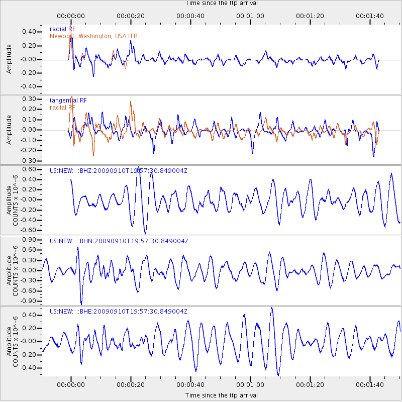
Signal To Noise
| Channel | StoN | STA | LTA |
| US:NEW: :BHN:20090910T19:57:30.849004Z | 2.0328712 | 3.9769233E-7 | 1.9563086E-7 |
| US:NEW: :BHE:20090910T19:57:30.849004Z | 0.81634873 | 1.5342476E-7 | 1.8794022E-7 |
| US:NEW: :BHZ:20090910T19:57:30.849004Z | 0.53750795 | 1.2599439E-7 | 2.344047E-7 |
| Arrivals |
| Ps | |
| PpPs | |
| PsPs/PpSs | |


