You are here: Home > Network List > US - United States National Seismic Network Stations List
> Station NEW Newport, Washington, USA > Earthquake Result Viewer
NEW Newport, Washington, USA - Earthquake Result Viewer
*The percent match for this event was below the threshold and hence no stack was calculated.
| Earthquake location: |
South Of Tonga Islands |
| Earthquake latitude/longitude: |
-24.1/-175.2 |
| Earthquake time(UTC): |
2009/11/02 (306) 10:47:13 GMT |
| Earthquake Depth: |
9.0 km |
| Earthquake Magnitude: |
6.1 MB, 6.1 MS, 6.2 MW, 6.1 MW |
| Earthquake Catalog/Contributor: |
WHDF/NEIC |
|
| Network: |
US United States National Seismic Network |
| Station: |
NEW Newport, Washington, USA |
| Lat/Lon: |
48.26 N/117.12 W |
| Elevation: |
760 m |
|
| Distance: |
88.8 deg |
| Az: |
34.549 deg |
| Baz: |
230.848 deg |
| Ray Param: |
$rayparam |
*The percent match for this event was below the threshold and hence was not used in the summary stack. |
|
| Radial Match: |
68.24214 % |
| Radial Bump: |
400 |
| Transverse Match: |
35.258762 % |
| Transverse Bump: |
378 |
| SOD ConfigId: |
2622 |
| Insert Time: |
2010-03-05 01:47:55.713 +0000 |
| GWidth: |
2.5 |
| Max Bumps: |
400 |
| Tol: |
0.001 |
|
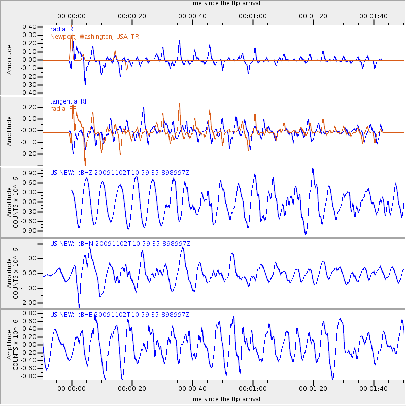
Signal To Noise
| Channel | StoN | STA | LTA |
| US:NEW: :BHN:20091102T10:59:35.898997Z | 3.7350552 | 9.0613867E-7 | 2.4260382E-7 |
| US:NEW: :BHE:20091102T10:59:35.898997Z | 0.634829 | 2.588759E-7 | 4.0778843E-7 |
| US:NEW: :BHZ:20091102T10:59:35.898997Z | 0.9636818 | 4.8617574E-7 | 5.044982E-7 |
| Arrivals |
| Ps | |
| PpPs | |
| PsPs/PpSs | |


