You are here: Home > Network List > UW - Pacific Northwest Regional Seismic Network Stations List
> Station HOOD Mt Hood Meadows, OR CREST BB SMO > Earthquake Result Viewer
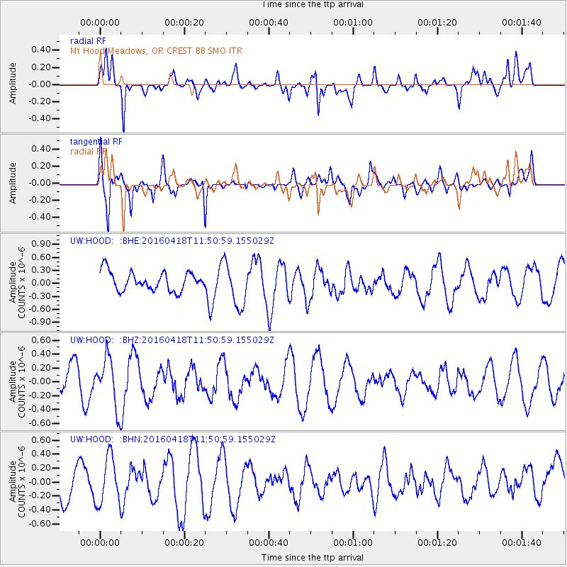
HOOD Mt Hood Meadows, OR CREST BB SMO - Earthquake Result Viewer
*The percent match for this event was below the threshold and hence no stack was calculated.
| Earthquake location: |
Near Coast Of Central Chile |
| Earthquake latitude/longitude: |
-31.7/-71.2 |
| Earthquake time(UTC): |
2016/04/18 (109) 11:38:38 GMT |
| Earthquake Depth: |
39 km |
| Earthquake Magnitude: |
5.6 MB |
| Earthquake Catalog/Contributor: |
NEIC PDE/NEIC ALERT |
|
| Network: |
UW Pacific Northwest Regional Seismic Network |
| Station: |
HOOD Mt Hood Meadows, OR CREST BB SMO |
| Lat/Lon: |
45.32 N/121.65 W |
| Elevation: |
1520 m |
|
| Distance: |
89.3 deg |
| Az: |
327.026 deg |
| Baz: |
138.894 deg |
| Ray Param: |
$rayparam |
*The percent match for this event was below the threshold and hence was not used in the summary stack. |
|
| Radial Match: |
62.12419 % |
| Radial Bump: |
400 |
| Transverse Match: |
77.38647 % |
| Transverse Bump: |
400 |
| SOD ConfigId: |
7422571 |
| Insert Time: |
2019-04-22 08:58:39.161 +0000 |
| GWidth: |
2.5 |
| Max Bumps: |
400 |
| Tol: |
0.001 |
|
Signal To Noise
| Channel | StoN | STA | LTA |
| UW:HOOD: :BHZ:20160418T11:50:59.155029Z | 1.8238063 | 3.7235307E-7 | 2.0416262E-7 |
| UW:HOOD: :BHN:20160418T11:50:59.155029Z | 1.3667947 | 3.4604983E-7 | 2.5318346E-7 |
| UW:HOOD: :BHE:20160418T11:50:59.155029Z | 2.4079616 | 5.1908415E-7 | 2.1556994E-7 |
| Arrivals |
| Ps | |
| PpPs | |
| PsPs/PpSs | |


