You are here: Home > Network List > TA - USArray Transportable Network (new EarthScope stations) Stations List
> Station 109C Camp Elliot, Mirimar, CA, USA > Earthquake Result Viewer
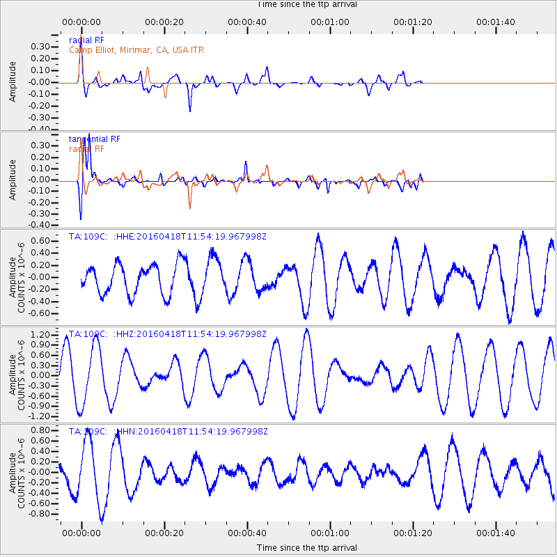
109C Camp Elliot, Mirimar, CA, USA - Earthquake Result Viewer
*The percent match for this event was below the threshold and hence no stack was calculated.
| Earthquake location: |
Kyushu, Japan |
| Earthquake latitude/longitude: |
33.0/131.1 |
| Earthquake time(UTC): |
2016/04/18 (109) 11:41:59 GMT |
| Earthquake Depth: |
7.7 km |
| Earthquake Magnitude: |
5.5 MWW, 5.4 MWR, 5.5 MWC |
| Earthquake Catalog/Contributor: |
NEIC PDE/NEIC COMCAT |
|
| Network: |
TA USArray Transportable Network (new EarthScope stations) |
| Station: |
109C Camp Elliot, Mirimar, CA, USA |
| Lat/Lon: |
32.89 N/117.11 W |
| Elevation: |
150 m |
|
| Distance: |
88.2 deg |
| Az: |
51.41 deg |
| Baz: |
308.69 deg |
| Ray Param: |
$rayparam |
*The percent match for this event was below the threshold and hence was not used in the summary stack. |
|
| Radial Match: |
71.85807 % |
| Radial Bump: |
400 |
| Transverse Match: |
81.48254 % |
| Transverse Bump: |
392 |
| SOD ConfigId: |
7422571 |
| Insert Time: |
2019-04-22 09:08:40.070 +0000 |
| GWidth: |
2.5 |
| Max Bumps: |
400 |
| Tol: |
0.001 |
|
Signal To Noise
| Channel | StoN | STA | LTA |
| TA:109C: :HHZ:20160418T11:54:19.967998Z | 3.543348 | 9.0462197E-7 | 2.5530147E-7 |
| TA:109C: :HHN:20160418T11:54:19.967998Z | 2.5922456 | 5.712327E-7 | 2.203621E-7 |
| TA:109C: :HHE:20160418T11:54:19.967998Z | 1.2302698 | 2.9537614E-7 | 2.4009051E-7 |
| Arrivals |
| Ps | |
| PpPs | |
| PsPs/PpSs | |


