You are here: Home > Network List > UW - Pacific Northwest Regional Seismic Network Stations List
> Station LEBA Lebam, WA, USA > Earthquake Result Viewer
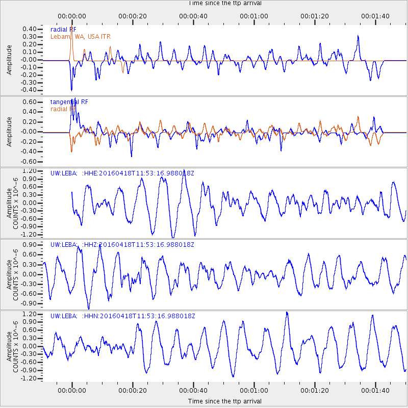
LEBA Lebam, WA, USA - Earthquake Result Viewer
*The percent match for this event was below the threshold and hence no stack was calculated.
| Earthquake location: |
Kyushu, Japan |
| Earthquake latitude/longitude: |
33.0/131.1 |
| Earthquake time(UTC): |
2016/04/18 (109) 11:41:59 GMT |
| Earthquake Depth: |
7.7 km |
| Earthquake Magnitude: |
5.5 MWW, 5.4 MWR, 5.5 MWC |
| Earthquake Catalog/Contributor: |
NEIC PDE/NEIC COMCAT |
|
| Network: |
UW Pacific Northwest Regional Seismic Network |
| Station: |
LEBA Lebam, WA, USA |
| Lat/Lon: |
46.55 N/123.56 W |
| Elevation: |
73 m |
|
| Distance: |
76.2 deg |
| Az: |
43.276 deg |
| Baz: |
303.437 deg |
| Ray Param: |
$rayparam |
*The percent match for this event was below the threshold and hence was not used in the summary stack. |
|
| Radial Match: |
47.602642 % |
| Radial Bump: |
400 |
| Transverse Match: |
88.7742 % |
| Transverse Bump: |
400 |
| SOD ConfigId: |
7422571 |
| Insert Time: |
2019-04-22 09:09:38.712 +0000 |
| GWidth: |
2.5 |
| Max Bumps: |
400 |
| Tol: |
0.001 |
|
Signal To Noise
| Channel | StoN | STA | LTA |
| UW:LEBA: :HHZ:20160418T11:53:16.988018Z | 2.13688 | 5.5752963E-7 | 2.6090828E-7 |
| UW:LEBA: :HHN:20160418T11:53:16.988018Z | 0.996811 | 2.246365E-7 | 2.2535515E-7 |
| UW:LEBA: :HHE:20160418T11:53:16.988018Z | 1.993724 | 8.953233E-7 | 4.4907085E-7 |
| Arrivals |
| Ps | |
| PpPs | |
| PsPs/PpSs | |


