You are here: Home > Network List > US - United States National Seismic Network Stations List
> Station MCWV Mont Chateau, West Virginia, USA > Earthquake Result Viewer
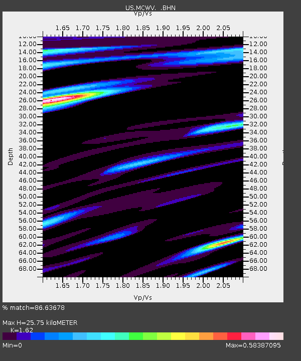
MCWV Mont Chateau, West Virginia, USA - Earthquake Result Viewer
| Earthquake location: |
Kuril Islands |
| Earthquake latitude/longitude: |
44.2/148.5 |
| Earthquake time(UTC): |
2001/06/24 (175) 13:18:51 GMT |
| Earthquake Depth: |
33 km |
| Earthquake Magnitude: |
5.8 MB, 5.7 MS, 6.0 MW |
| Earthquake Catalog/Contributor: |
WHDF/NEIC |
|
| Network: |
US United States National Seismic Network |
| Station: |
MCWV Mont Chateau, West Virginia, USA |
| Lat/Lon: |
39.66 N/79.85 W |
| Elevation: |
280 m |
|
| Distance: |
85.8 deg |
| Az: |
35.338 deg |
| Baz: |
327.384 deg |
| Ray Param: |
0.044432912 |
| Estimated Moho Depth: |
25.75 km |
| Estimated Crust Vp/Vs: |
1.62 |
| Assumed Crust Vp: |
6.159 km/s |
| Estimated Crust Vs: |
3.802 km/s |
| Estimated Crust Poisson's Ratio: |
0.19 |
|
| Radial Match: |
86.63678 % |
| Radial Bump: |
400 |
| Transverse Match: |
68.18678 % |
| Transverse Bump: |
400 |
| SOD ConfigId: |
110165 |
| Insert Time: |
2010-03-05 01:49:04.071 +0000 |
| GWidth: |
2.5 |
| Max Bumps: |
400 |
| Tol: |
0.001 |
|

Signal To Noise
| Channel | StoN | STA | LTA |
| US:MCWV: :BHN:20010624T13:30:56.751016Z | 1.9949051 | 1.3041586E-7 | 6.5374465E-8 |
| US:MCWV: :BHE:20010624T13:30:56.751016Z | 1.4126793 | 7.964938E-8 | 5.6381783E-8 |
| US:MCWV: :BHZ:20010624T13:30:56.751016Z | 6.3698916 | 5.831036E-7 | 9.154059E-8 |
| Arrivals |
| Ps | 2.7 SECOND |
| PpPs | 11 SECOND |
| PsPs/PpSs | 13 SECOND |


