You are here: Home > Network List > US - United States National Seismic Network Stations List
> Station MCWV Mont Chateau, West Virginia, USA > Earthquake Result Viewer
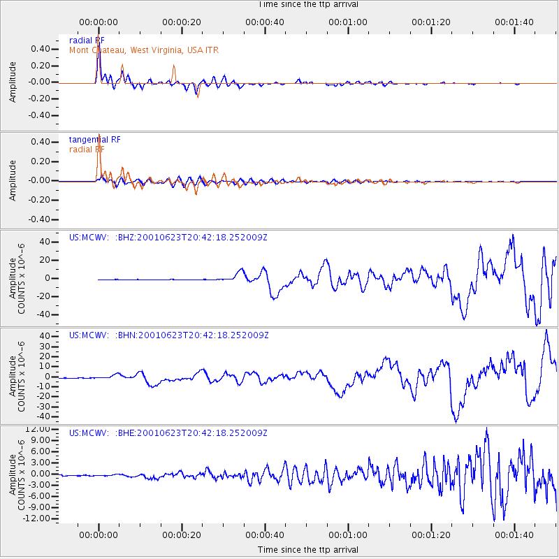
MCWV Mont Chateau, West Virginia, USA - Earthquake Result Viewer

| Earthquake location: |
Near Coast Of Peru |
| Earthquake latitude/longitude: |
-16.3/-73.6 |
| Earthquake time(UTC): |
2001/06/23 (174) 20:33:14 GMT |
| Earthquake Depth: |
33 km |
| Earthquake Magnitude: |
6.7 MB, 8.2 MS, 8.4 MW, 7.8 ME |
| Earthquake Catalog/Contributor: |
WHDF/NEIC |
|
| Network: |
US United States National Seismic Network |
| Station: |
MCWV Mont Chateau, West Virginia, USA |
| Lat/Lon: |
39.66 N/79.85 W |
| Elevation: |
280 m |
|
| Distance: |
55.9 deg |
| Az: |
354.219 deg |
| Baz: |
172.801 deg |
| Ray Param: |
0.06441243 |
| Estimated Moho Depth: |
69.25 km |
| Estimated Crust Vp/Vs: |
1.60 |
| Assumed Crust Vp: |
6.159 km/s |
| Estimated Crust Vs: |
3.849 km/s |
| Estimated Crust Poisson's Ratio: |
0.18 |
|
| Radial Match: |
98.43884 % |
| Radial Bump: |
400 |
| Transverse Match: |
85.19849 % |
| Transverse Bump: |
400 |
| SOD ConfigId: |
110165 |
| Insert Time: |
2010-03-05 01:49:05.205 +0000 |
| GWidth: |
2.5 |
| Max Bumps: |
400 |
| Tol: |
0.001 |
|
Signal To Noise
| Channel | StoN | STA | LTA |
| US:MCWV: :BHN:20010623T20:42:18.252009Z | 31.141443 | 2.18654E-6 | 7.021319E-8 |
| US:MCWV: :BHE:20010623T20:42:18.252009Z | 2.8050382 | 1.8367045E-7 | 6.547877E-8 |
| US:MCWV: :BHZ:20010623T20:42:18.252009Z | 53.624184 | 5.707273E-6 | 1.0643096E-7 |
| Arrivals |
| Ps | 7.1 SECOND |
| PpPs | 28 SECOND |
| PsPs/PpSs | 35 SECOND |


