You are here: Home > Network List > US - United States National Seismic Network Stations List
> Station MCWV Mont Chateau, West Virginia, USA > Earthquake Result Viewer
MCWV Mont Chateau, West Virginia, USA - Earthquake Result Viewer
| Earthquake location: |
Greece-Albania Border Region |
| Earthquake latitude/longitude: |
39.2/20.6 |
| Earthquake time(UTC): |
2003/08/14 (226) 05:14:54 GMT |
| Earthquake Depth: |
10 km |
| Earthquake Magnitude: |
5.6 MB, 6.2 MS, 6.3 MW, 6.2 MW |
| Earthquake Catalog/Contributor: |
WHDF/NEIC |
|
| Network: |
US United States National Seismic Network |
| Station: |
MCWV Mont Chateau, West Virginia, USA |
| Lat/Lon: |
39.66 N/79.85 W |
| Elevation: |
280 m |
|
| Distance: |
73.1 deg |
| Az: |
307.488 deg |
| Baz: |
53.047 deg |
| Ray Param: |
0.053235028 |
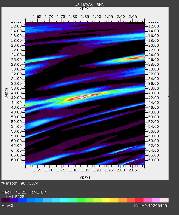
| Estimated Moho Depth: |
41.25 km |
| Estimated Crust Vp/Vs: |
1.84 |
| Assumed Crust Vp: |
6.159 km/s |
| Estimated Crust Vs: |
3.343 km/s |
| Estimated Crust Poisson's Ratio: |
0.29 |
|
| Radial Match: |
90.73374 % |
| Radial Bump: |
400 |
| Transverse Match: |
75.65388 % |
| Transverse Bump: |
400 |
| SOD ConfigId: |
110165 |
| Insert Time: |
2010-03-05 01:49:29.107 +0000 |
| GWidth: |
2.5 |
| Max Bumps: |
400 |
| Tol: |
0.001 |
|

Signal To Noise
| Channel | StoN | STA | LTA |
| US:MCWV: :BHN:20030814T05:25:53.752004Z | 0.9377155 | 8.5796366E-8 | 9.1495096E-8 |
| US:MCWV: :BHE:20030814T05:25:53.752004Z | 1.3953005 | 9.7551315E-8 | 6.991419E-8 |
| US:MCWV: :BHZ:20030814T05:25:53.752004Z | 0.9289675 | 1.3844331E-7 | 1.4902923E-7 |
| Arrivals |
| Ps | 5.8 SECOND |
| PpPs | 18 SECOND |
| PsPs/PpSs | 24 SECOND |


