You are here: Home > Network List > US - United States National Seismic Network Stations List
> Station MCWV Mont Chateau, West Virginia, USA > Earthquake Result Viewer
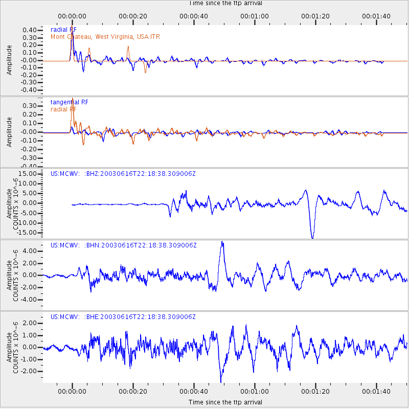
MCWV Mont Chateau, West Virginia, USA - Earthquake Result Viewer

| Earthquake location: |
Kamchatka Peninsula, Russia |
| Earthquake latitude/longitude: |
55.5/160.0 |
| Earthquake time(UTC): |
2003/06/16 (167) 22:08:02 GMT |
| Earthquake Depth: |
175 km |
| Earthquake Magnitude: |
6.3 MB, 6.9 MW, 6.9 MW |
| Earthquake Catalog/Contributor: |
WHDF/NEIC |
|
| Network: |
US United States National Seismic Network |
| Station: |
MCWV Mont Chateau, West Virginia, USA |
| Lat/Lon: |
39.66 N/79.85 W |
| Elevation: |
280 m |
|
| Distance: |
72.4 deg |
| Az: |
44.442 deg |
| Baz: |
328.923 deg |
| Ray Param: |
0.053210624 |
| Estimated Moho Depth: |
27.75 km |
| Estimated Crust Vp/Vs: |
1.60 |
| Assumed Crust Vp: |
6.159 km/s |
| Estimated Crust Vs: |
3.843 km/s |
| Estimated Crust Poisson's Ratio: |
0.18 |
|
| Radial Match: |
97.345085 % |
| Radial Bump: |
400 |
| Transverse Match: |
92.24181 % |
| Transverse Bump: |
400 |
| SOD ConfigId: |
110177 |
| Insert Time: |
2010-03-05 01:49:36.805 +0000 |
| GWidth: |
2.5 |
| Max Bumps: |
400 |
| Tol: |
0.001 |
|
Signal To Noise
| Channel | StoN | STA | LTA |
| US:MCWV: :BHN:20030616T22:18:38.309006Z | 3.5463054 | 5.9365436E-7 | 1.674008E-7 |
| US:MCWV: :BHE:20030616T22:18:38.309006Z | 2.540673 | 2.7843654E-7 | 1.0959165E-7 |
| US:MCWV: :BHZ:20030616T22:18:38.309006Z | 11.805218 | 2.2244622E-6 | 1.884304E-7 |
| Arrivals |
| Ps | 2.8 SECOND |
| PpPs | 11 SECOND |
| PsPs/PpSs | 14 SECOND |


