You are here: Home > Network List > AV - Alaska Volcano Observatory Stations List
> Station MAPS Pakushin Southeast, Makushin Volcano, Alaska > Earthquake Result Viewer
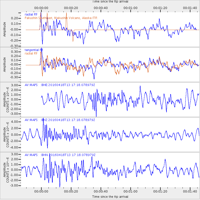
MAPS Pakushin Southeast, Makushin Volcano, Alaska - Earthquake Result Viewer
*The percent match for this event was below the threshold and hence no stack was calculated.
| Earthquake location: |
Vanuatu Islands |
| Earthquake latitude/longitude: |
-19.5/169.0 |
| Earthquake time(UTC): |
2016/04/18 (109) 13:06:11 GMT |
| Earthquake Depth: |
74 km |
| Earthquake Magnitude: |
5.9 MO |
| Earthquake Catalog/Contributor: |
NEIC PDE/NEIC ALERT |
|
| Network: |
AV Alaska Volcano Observatory |
| Station: |
MAPS Pakushin Southeast, Makushin Volcano, Alaska |
| Lat/Lon: |
53.81 N/166.94 W |
| Elevation: |
333 m |
|
| Distance: |
75.9 deg |
| Az: |
14.419 deg |
| Baz: |
203.336 deg |
| Ray Param: |
$rayparam |
*The percent match for this event was below the threshold and hence was not used in the summary stack. |
|
| Radial Match: |
55.750134 % |
| Radial Bump: |
400 |
| Transverse Match: |
55.258938 % |
| Transverse Bump: |
400 |
| SOD ConfigId: |
7422571 |
| Insert Time: |
2019-04-22 09:14:04.087 +0000 |
| GWidth: |
2.5 |
| Max Bumps: |
400 |
| Tol: |
0.001 |
|
Signal To Noise
| Channel | StoN | STA | LTA |
| AV:MAPS: :BHZ:20160418T13:17:18.078979Z | 3.3905206 | 2.3840282E-6 | 7.031452E-7 |
| AV:MAPS: :BHN:20160418T13:17:18.078979Z | 2.293226 | 1.2463389E-6 | 5.4348715E-7 |
| AV:MAPS: :BHE:20160418T13:17:18.078979Z | 1.2431757 | 1.0615289E-6 | 8.538848E-7 |
| Arrivals |
| Ps | |
| PpPs | |
| PsPs/PpSs | |


