You are here: Home > Network List > US - United States National Seismic Network Stations List
> Station MCWV Mont Chateau, West Virginia, USA > Earthquake Result Viewer
MCWV Mont Chateau, West Virginia, USA - Earthquake Result Viewer
| Earthquake location: |
Queen Charlotte Islands Region |
| Earthquake latitude/longitude: |
54.8/-134.2 |
| Earthquake time(UTC): |
2004/06/28 (180) 09:49:47 GMT |
| Earthquake Depth: |
20 km |
| Earthquake Magnitude: |
5.9 MB, 6.8 MS, 6.8 MW, 6.8 MW |
| Earthquake Catalog/Contributor: |
WHDF/NEIC |
|
| Network: |
US United States National Seismic Network |
| Station: |
MCWV Mont Chateau, West Virginia, USA |
| Lat/Lon: |
39.66 N/79.85 W |
| Elevation: |
280 m |
|
| Distance: |
38.9 deg |
| Az: |
89.844 deg |
| Baz: |
311.405 deg |
| Ray Param: |
0.07527985 |
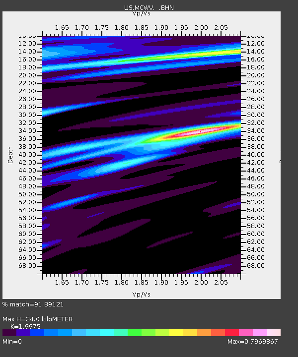
| Estimated Moho Depth: |
34.0 km |
| Estimated Crust Vp/Vs: |
2.00 |
| Assumed Crust Vp: |
6.159 km/s |
| Estimated Crust Vs: |
3.083 km/s |
| Estimated Crust Poisson's Ratio: |
0.33 |
|
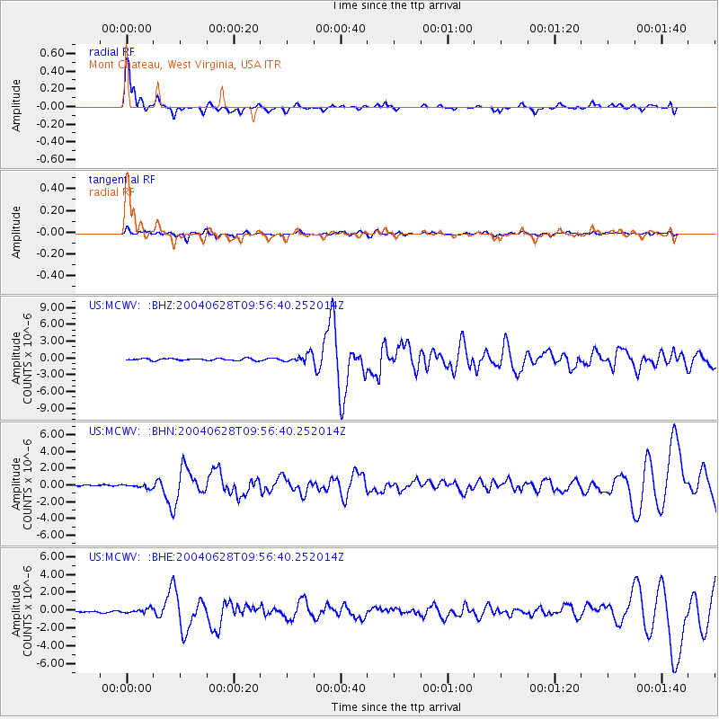
| Radial Match: |
91.89121 % |
| Radial Bump: |
362 |
| Transverse Match: |
58.33816 % |
| Transverse Bump: |
400 |
| SOD ConfigId: |
110177 |
| Insert Time: |
2010-03-05 01:49:54.317 +0000 |
| GWidth: |
2.5 |
| Max Bumps: |
400 |
| Tol: |
0.001 |
|
Signal To Noise
| Channel | StoN | STA | LTA |
| US:MCWV: :BHN:20040628T09:56:40.252014Z | 1.5614265 | 2.2330914E-7 | 1.4301611E-7 |
| US:MCWV: :BHE:20040628T09:56:40.252014Z | 3.0188663 | 2.3986294E-7 | 7.9454644E-8 |
| US:MCWV: :BHZ:20040628T09:56:40.252014Z | 4.3319364 | 7.443369E-7 | 1.7182543E-7 |
| Arrivals |
| Ps | 5.8 SECOND |
| PpPs | 16 SECOND |
| PsPs/PpSs | 21 SECOND |


