You are here: Home > Network List > US - United States National Seismic Network Stations List
> Station MCWV Mont Chateau, West Virginia, USA > Earthquake Result Viewer
MCWV Mont Chateau, West Virginia, USA - Earthquake Result Viewer

| Earthquake location: |
Peru-Ecuador Border Region |
| Earthquake latitude/longitude: |
-2.3/-77.8 |
| Earthquake time(UTC): |
2007/11/16 (320) 03:13:00 GMT |
| Earthquake Depth: |
123 km |
| Earthquake Magnitude: |
6.3 MB, 6.8 MW, 6.7 MW |
| Earthquake Catalog/Contributor: |
WHDF/NEIC |
|
| Network: |
US United States National Seismic Network |
| Station: |
MCWV Mont Chateau, West Virginia, USA |
| Lat/Lon: |
39.66 N/79.85 W |
| Elevation: |
280 m |
|
| Distance: |
41.8 deg |
| Az: |
357.675 deg |
| Baz: |
176.99 deg |
| Ray Param: |
0.073129825 |
| Estimated Moho Depth: |
40.5 km |
| Estimated Crust Vp/Vs: |
1.72 |
| Assumed Crust Vp: |
6.159 km/s |
| Estimated Crust Vs: |
3.575 km/s |
| Estimated Crust Poisson's Ratio: |
0.25 |
|
| Radial Match: |
91.898094 % |
| Radial Bump: |
400 |
| Transverse Match: |
76.16714 % |
| Transverse Bump: |
400 |
| SOD ConfigId: |
2564 |
| Insert Time: |
2010-03-05 01:50:15.297 +0000 |
| GWidth: |
2.5 |
| Max Bumps: |
400 |
| Tol: |
0.001 |
|
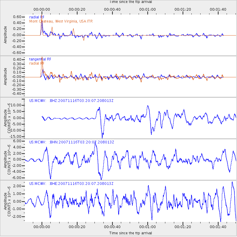
Signal To Noise
| Channel | StoN | STA | LTA |
| US:MCWV: :BHN:20071116T03:20:07.208013Z | 7.079061 | 2.5872068E-6 | 3.6547314E-7 |
| US:MCWV: :BHE:20071116T03:20:07.208013Z | 1.9799212 | 8.5889974E-7 | 4.33805E-7 |
| US:MCWV: :BHZ:20071116T03:20:07.208013Z | 12.150837 | 6.879829E-6 | 5.6620206E-7 |
| Arrivals |
| Ps | 5.1 SECOND |
| PpPs | 17 SECOND |
| PsPs/PpSs | 22 SECOND |


