You are here: Home > Network List > TA - USArray Transportable Network (new EarthScope stations) Stations List
> Station J26L Joseph Creek, AK, USA > Earthquake Result Viewer
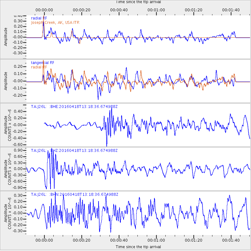
J26L Joseph Creek, AK, USA - Earthquake Result Viewer
*The percent match for this event was below the threshold and hence no stack was calculated.
| Earthquake location: |
Vanuatu Islands |
| Earthquake latitude/longitude: |
-19.5/169.0 |
| Earthquake time(UTC): |
2016/04/18 (109) 13:06:11 GMT |
| Earthquake Depth: |
74 km |
| Earthquake Magnitude: |
5.9 MO |
| Earthquake Catalog/Contributor: |
NEIC PDE/NEIC ALERT |
|
| Network: |
TA USArray Transportable Network (new EarthScope stations) |
| Station: |
J26L Joseph Creek, AK, USA |
| Lat/Lon: |
64.50 N/143.56 W |
| Elevation: |
1144 m |
|
| Distance: |
91.3 deg |
| Az: |
18.585 deg |
| Baz: |
224.002 deg |
| Ray Param: |
$rayparam |
*The percent match for this event was below the threshold and hence was not used in the summary stack. |
|
| Radial Match: |
59.405796 % |
| Radial Bump: |
400 |
| Transverse Match: |
69.29953 % |
| Transverse Bump: |
400 |
| SOD ConfigId: |
7422571 |
| Insert Time: |
2019-04-22 09:19:03.546 +0000 |
| GWidth: |
2.5 |
| Max Bumps: |
400 |
| Tol: |
0.001 |
|
Signal To Noise
| Channel | StoN | STA | LTA |
| TA:J26L: :BHZ:20160418T13:18:36.674988Z | 6.6633115 | 6.1065765E-7 | 9.1644765E-8 |
| TA:J26L: :BHN:20160418T13:18:36.674988Z | 2.429045 | 1.3970015E-7 | 5.7512374E-8 |
| TA:J26L: :BHE:20160418T13:18:36.674988Z | 4.184385 | 2.134982E-7 | 5.10226E-8 |
| Arrivals |
| Ps | |
| PpPs | |
| PsPs/PpSs | |


