You are here: Home > Network List > US - United States National Seismic Network Stations List
> Station MCWV Mont Chateau, West Virginia, USA > Earthquake Result Viewer
MCWV Mont Chateau, West Virginia, USA - Earthquake Result Viewer
| Earthquake location: |
Sea Of Okhotsk |
| Earthquake latitude/longitude: |
53.9/152.9 |
| Earthquake time(UTC): |
2008/07/05 (187) 02:12:04 GMT |
| Earthquake Depth: |
633 km |
| Earthquake Magnitude: |
6.8 MB, 7.7 MW, 7.7 MW |
| Earthquake Catalog/Contributor: |
WHDF/NEIC |
|
| Network: |
US United States National Seismic Network |
| Station: |
MCWV Mont Chateau, West Virginia, USA |
| Lat/Lon: |
39.66 N/79.85 W |
| Elevation: |
280 m |
|
| Distance: |
76.4 deg |
| Az: |
39.207 deg |
| Baz: |
331.002 deg |
| Ray Param: |
0.048964947 |
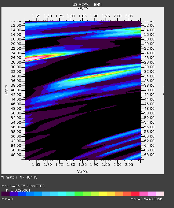
| Estimated Moho Depth: |
26.25 km |
| Estimated Crust Vp/Vs: |
1.62 |
| Assumed Crust Vp: |
6.159 km/s |
| Estimated Crust Vs: |
3.796 km/s |
| Estimated Crust Poisson's Ratio: |
0.19 |
|
| Radial Match: |
97.48443 % |
| Radial Bump: |
400 |
| Transverse Match: |
93.196556 % |
| Transverse Bump: |
400 |
| SOD ConfigId: |
2504 |
| Insert Time: |
2010-03-05 01:50:52.219 +0000 |
| GWidth: |
2.5 |
| Max Bumps: |
400 |
| Tol: |
0.001 |
|
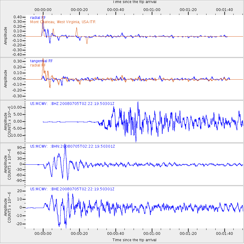
Signal To Noise
| Channel | StoN | STA | LTA |
| US:MCWV: :BHN:20080705T02:22:19.50301Z | 90.74409 | 2.2381899E-5 | 2.4664854E-7 |
| US:MCWV: :BHE:20080705T02:22:19.50301Z | 33.384 | 5.33617E-6 | 1.5984214E-7 |
| US:MCWV: :BHZ:20080705T02:22:19.50301Z | 17.26683 | 1.951183E-6 | 1.1300182E-7 |
| Arrivals |
| Ps | 2.7 SECOND |
| PpPs | 11 SECOND |
| PsPs/PpSs | 14 SECOND |


