You are here: Home > Network List > TA - USArray Transportable Network (new EarthScope stations) Stations List
> Station R11A Troy Canyon, Currant, NV, USA > Earthquake Result Viewer
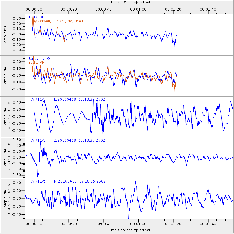
R11A Troy Canyon, Currant, NV, USA - Earthquake Result Viewer
*The percent match for this event was below the threshold and hence no stack was calculated.
| Earthquake location: |
Vanuatu Islands |
| Earthquake latitude/longitude: |
-19.5/169.0 |
| Earthquake time(UTC): |
2016/04/18 (109) 13:06:11 GMT |
| Earthquake Depth: |
74 km |
| Earthquake Magnitude: |
5.9 MO |
| Earthquake Catalog/Contributor: |
NEIC PDE/NEIC ALERT |
|
| Network: |
TA USArray Transportable Network (new EarthScope stations) |
| Station: |
R11A Troy Canyon, Currant, NV, USA |
| Lat/Lon: |
38.35 N/115.59 W |
| Elevation: |
1756 m |
|
| Distance: |
91.0 deg |
| Az: |
49.546 deg |
| Baz: |
245.932 deg |
| Ray Param: |
$rayparam |
*The percent match for this event was below the threshold and hence was not used in the summary stack. |
|
| Radial Match: |
60.655018 % |
| Radial Bump: |
364 |
| Transverse Match: |
76.88311 % |
| Transverse Bump: |
389 |
| SOD ConfigId: |
7422571 |
| Insert Time: |
2019-04-22 09:19:34.557 +0000 |
| GWidth: |
2.5 |
| Max Bumps: |
400 |
| Tol: |
0.001 |
|
Signal To Noise
| Channel | StoN | STA | LTA |
| TA:R11A: :HHZ:20160418T13:18:35.250Z | 3.2061992 | 8.386729E-7 | 2.6157855E-7 |
| TA:R11A: :HHN:20160418T13:18:35.250Z | 0.9533207 | 1.12233984E-7 | 1.1772951E-7 |
| TA:R11A: :HHE:20160418T13:18:35.250Z | 1.0104036 | 2.2962999E-7 | 2.2726562E-7 |
| Arrivals |
| Ps | |
| PpPs | |
| PsPs/PpSs | |


