You are here: Home > Network List > UW - Pacific Northwest Regional Seismic Network Stations List
> Station LEBA Lebam, WA, USA > Earthquake Result Viewer
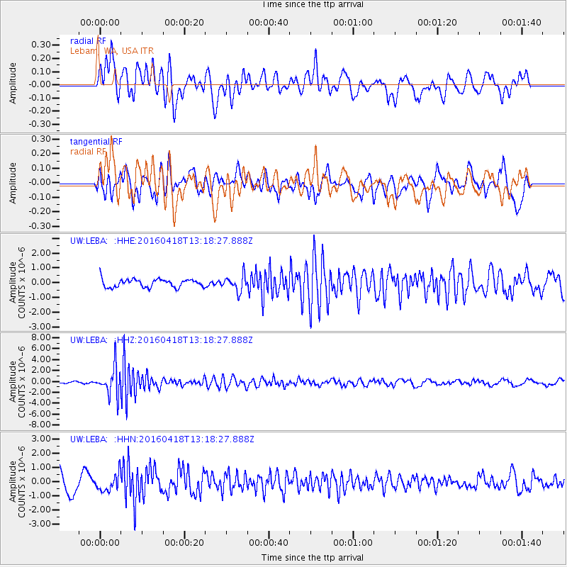
LEBA Lebam, WA, USA - Earthquake Result Viewer
*The percent match for this event was below the threshold and hence no stack was calculated.
| Earthquake location: |
Vanuatu Islands |
| Earthquake latitude/longitude: |
-19.5/169.0 |
| Earthquake time(UTC): |
2016/04/18 (109) 13:06:11 GMT |
| Earthquake Depth: |
74 km |
| Earthquake Magnitude: |
5.9 MO |
| Earthquake Catalog/Contributor: |
NEIC PDE/NEIC ALERT |
|
| Network: |
UW Pacific Northwest Regional Seismic Network |
| Station: |
LEBA Lebam, WA, USA |
| Lat/Lon: |
46.55 N/123.56 W |
| Elevation: |
73 m |
|
| Distance: |
89.4 deg |
| Az: |
39.587 deg |
| Baz: |
240.585 deg |
| Ray Param: |
$rayparam |
*The percent match for this event was below the threshold and hence was not used in the summary stack. |
|
| Radial Match: |
73.44244 % |
| Radial Bump: |
400 |
| Transverse Match: |
59.713814 % |
| Transverse Bump: |
400 |
| SOD ConfigId: |
7422571 |
| Insert Time: |
2019-04-22 09:20:15.233 +0000 |
| GWidth: |
2.5 |
| Max Bumps: |
400 |
| Tol: |
0.001 |
|
Signal To Noise
| Channel | StoN | STA | LTA |
| UW:LEBA: :HHZ:20160418T13:18:27.888Z | 7.9677978 | 2.616426E-6 | 3.2837505E-7 |
| UW:LEBA: :HHN:20160418T13:18:27.888Z | 0.85695314 | 6.183967E-7 | 7.216226E-7 |
| UW:LEBA: :HHE:20160418T13:18:27.888Z | 2.1227753 | 5.369418E-7 | 2.529433E-7 |
| Arrivals |
| Ps | |
| PpPs | |
| PsPs/PpSs | |


