You are here: Home > Network List > UW - Pacific Northwest Regional Seismic Network Stations List
> Station PASS Maple Falls, WA, USA > Earthquake Result Viewer
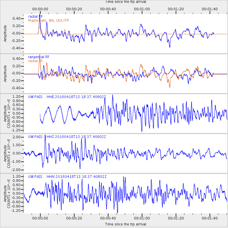
PASS Maple Falls, WA, USA - Earthquake Result Viewer
*The percent match for this event was below the threshold and hence no stack was calculated.
| Earthquake location: |
Vanuatu Islands |
| Earthquake latitude/longitude: |
-19.5/169.0 |
| Earthquake time(UTC): |
2016/04/18 (109) 13:06:11 GMT |
| Earthquake Depth: |
74 km |
| Earthquake Magnitude: |
5.9 MO |
| Earthquake Catalog/Contributor: |
NEIC PDE/NEIC ALERT |
|
| Network: |
UW Pacific Northwest Regional Seismic Network |
| Station: |
PASS Maple Falls, WA, USA |
| Lat/Lon: |
49.00 N/122.09 W |
| Elevation: |
174 m |
|
| Distance: |
91.5 deg |
| Az: |
37.92 deg |
| Baz: |
241.689 deg |
| Ray Param: |
$rayparam |
*The percent match for this event was below the threshold and hence was not used in the summary stack. |
|
| Radial Match: |
70.5153 % |
| Radial Bump: |
400 |
| Transverse Match: |
47.45158 % |
| Transverse Bump: |
400 |
| SOD ConfigId: |
7422571 |
| Insert Time: |
2019-04-22 09:20:18.637 +0000 |
| GWidth: |
2.5 |
| Max Bumps: |
400 |
| Tol: |
0.001 |
|
Signal To Noise
| Channel | StoN | STA | LTA |
| UW:PASS: :HHZ:20160418T13:18:37.40802Z | 6.108888 | 9.066141E-7 | 1.4840901E-7 |
| UW:PASS: :HHN:20160418T13:18:37.40802Z | 0.7391195 | 2.867325E-7 | 3.8793792E-7 |
| UW:PASS: :HHE:20160418T13:18:37.40802Z | 0.68007123 | 2.4379534E-7 | 3.58485E-7 |
| Arrivals |
| Ps | |
| PpPs | |
| PsPs/PpSs | |


