You are here: Home > Network List > US - United States National Seismic Network Stations List
> Station MCWV Mont Chateau, West Virginia, USA > Earthquake Result Viewer
MCWV Mont Chateau, West Virginia, USA - Earthquake Result Viewer
| Earthquake location: |
Off Coast Of Northern Peru |
| Earthquake latitude/longitude: |
-9.6/-79.6 |
| Earthquake time(UTC): |
1996/02/21 (052) 12:51:04 GMT |
| Earthquake Depth: |
33 km |
| Earthquake Magnitude: |
5.8 MB, 6.6 MS, 7.5 UNKNOWN, 7.3 MW |
| Earthquake Catalog/Contributor: |
WHDF/NEIC |
|
| Network: |
US United States National Seismic Network |
| Station: |
MCWV Mont Chateau, West Virginia, USA |
| Lat/Lon: |
39.66 N/79.85 W |
| Elevation: |
280 m |
|
| Distance: |
49.0 deg |
| Az: |
359.716 deg |
| Baz: |
179.637 deg |
| Ray Param: |
0.06890265 |
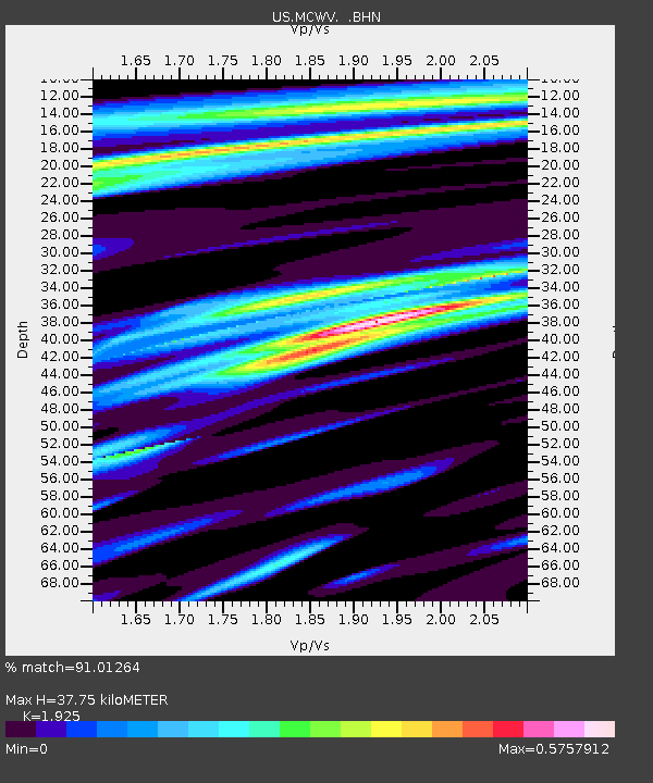
| Estimated Moho Depth: |
37.75 km |
| Estimated Crust Vp/Vs: |
1.92 |
| Assumed Crust Vp: |
6.159 km/s |
| Estimated Crust Vs: |
3.199 km/s |
| Estimated Crust Poisson's Ratio: |
0.32 |
|
| Radial Match: |
91.01264 % |
| Radial Bump: |
400 |
| Transverse Match: |
77.10865 % |
| Transverse Bump: |
400 |
| SOD ConfigId: |
110177 |
| Insert Time: |
2010-03-05 01:51:10.647 +0000 |
| GWidth: |
2.5 |
| Max Bumps: |
400 |
| Tol: |
0.001 |
|

Signal To Noise
| Channel | StoN | STA | LTA |
| US:MCWV: :BHN:19960221T12:59:17.388013Z | 0.33239093 | 6.9194203E-7 | 2.0817115E-6 |
| US:MCWV: :BHE:19960221T12:59:17.388013Z | 1.1583177 | 2.4509737E-7 | 2.115977E-7 |
| US:MCWV: :BHZ:19960221T12:59:17.388013Z | 4.341909 | 1.4537105E-6 | 3.3480907E-7 |
| Arrivals |
| Ps | 6.0 SECOND |
| PpPs | 17 SECOND |
| PsPs/PpSs | 23 SECOND |


