You are here: Home > Network List > US - United States National Seismic Network Stations List
> Station MCWV Mont Chateau, West Virginia, USA > Earthquake Result Viewer
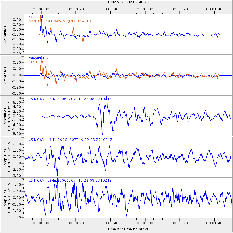
MCWV Mont Chateau, West Virginia, USA - Earthquake Result Viewer

| Earthquake location: |
East Of Kuril Islands |
| Earthquake latitude/longitude: |
46.2/154.4 |
| Earthquake time(UTC): |
2006/12/07 (341) 19:10:21 GMT |
| Earthquake Depth: |
16 km |
| Earthquake Magnitude: |
6.3 MB, 6.1 MS, 6.3 MW, 6.3 MW |
| Earthquake Catalog/Contributor: |
WHDF/NEIC |
|
| Network: |
US United States National Seismic Network |
| Station: |
MCWV Mont Chateau, West Virginia, USA |
| Lat/Lon: |
39.66 N/79.85 W |
| Elevation: |
280 m |
|
| Distance: |
81.8 deg |
| Az: |
39.264 deg |
| Baz: |
325.256 deg |
| Ray Param: |
0.0473481 |
| Estimated Moho Depth: |
27.0 km |
| Estimated Crust Vp/Vs: |
1.60 |
| Assumed Crust Vp: |
6.159 km/s |
| Estimated Crust Vs: |
3.849 km/s |
| Estimated Crust Poisson's Ratio: |
0.18 |
|
| Radial Match: |
89.31049 % |
| Radial Bump: |
400 |
| Transverse Match: |
72.2828 % |
| Transverse Bump: |
400 |
| SOD ConfigId: |
2564 |
| Insert Time: |
2010-03-05 01:51:42.747 +0000 |
| GWidth: |
2.5 |
| Max Bumps: |
400 |
| Tol: |
0.001 |
|
Signal To Noise
| Channel | StoN | STA | LTA |
| US:MCWV: :BHN:20061207T19:22:08.271021Z | 2.48513 | 6.8758146E-7 | 2.7667824E-7 |
| US:MCWV: :BHE:20061207T19:22:08.271021Z | 2.2037082 | 6.201325E-7 | 2.8140408E-7 |
| US:MCWV: :BHZ:20061207T19:22:08.271021Z | 7.0496793 | 2.6573437E-6 | 3.7694534E-7 |
| Arrivals |
| Ps | 2.7 SECOND |
| PpPs | 11 SECOND |
| PsPs/PpSs | 14 SECOND |


