You are here: Home > Network List > EC - Ecuador Seismic Network Stations List
> Station PULU OVPULU_S > Earthquake Result Viewer
PULU OVPULU_S - Earthquake Result Viewer
| Earthquake location: |
South Sandwich Islands Region |
| Earthquake latitude/longitude: |
-55.6/-27.2 |
| Earthquake time(UTC): |
2016/04/19 (110) 05:25:39 GMT |
| Earthquake Depth: |
11 km |
| Earthquake Magnitude: |
5.9 MB |
| Earthquake Catalog/Contributor: |
NEIC PDE/NEIC COMCAT |
|
| Network: |
EC Ecuador Seismic Network |
| Station: |
PULU OVPULU_S |
| Lat/Lon: |
0.02 N/78.50 W |
| Elevation: |
3114 m |
|
| Distance: |
69.2 deg |
| Az: |
303.456 deg |
| Baz: |
151.758 deg |
| Ray Param: |
0.055781193 |
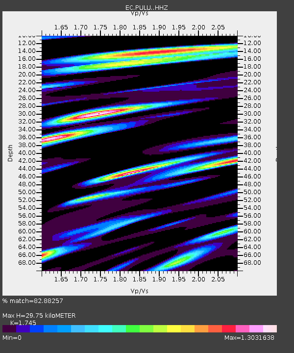
| Estimated Moho Depth: |
29.75 km |
| Estimated Crust Vp/Vs: |
1.75 |
| Assumed Crust Vp: |
6.472 km/s |
| Estimated Crust Vs: |
3.709 km/s |
| Estimated Crust Poisson's Ratio: |
0.26 |
|
| Radial Match: |
82.88257 % |
| Radial Bump: |
400 |
| Transverse Match: |
80.0469 % |
| Transverse Bump: |
400 |
| SOD ConfigId: |
7422571 |
| Insert Time: |
2019-04-22 09:24:51.443 +0000 |
| GWidth: |
2.5 |
| Max Bumps: |
400 |
| Tol: |
0.001 |
|

Signal To Noise
| Channel | StoN | STA | LTA |
| EC:PULU: :HHZ:20160419T05:36:15.368005Z | 6.164662 | 8.2235556E-7 | 1.3339832E-7 |
| EC:PULU: :HHN:20160419T05:36:15.368005Z | 1.0987271 | 7.731922E-7 | 7.0371635E-7 |
| EC:PULU: :HHE:20160419T05:36:15.368005Z | 1.1406097 | 7.887448E-7 | 6.915115E-7 |
| Arrivals |
| Ps | 3.6 SECOND |
| PpPs | 12 SECOND |
| PsPs/PpSs | 16 SECOND |


