You are here: Home > Network List > US - United States National Seismic Network Stations List
> Station MCWV Mont Chateau, West Virginia, USA > Earthquake Result Viewer
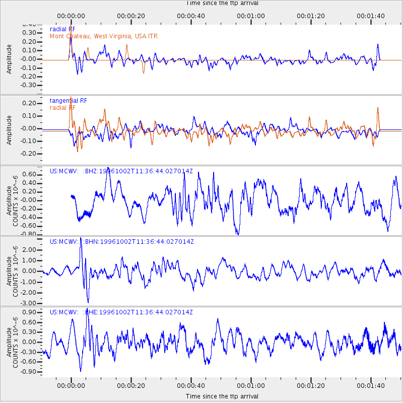
MCWV Mont Chateau, West Virginia, USA - Earthquake Result Viewer
*The percent match for this event was below the threshold and hence no stack was calculated.
| Earthquake location: |
Kuril Islands |
| Earthquake latitude/longitude: |
45.1/151.2 |
| Earthquake time(UTC): |
1996/10/02 (276) 11:24:48 GMT |
| Earthquake Depth: |
33 km |
| Earthquake Magnitude: |
6.1 MB, 5.4 MS, 6.0 UNKNOWN, 6.0 MW |
| Earthquake Catalog/Contributor: |
WHDF/NEIC |
|
| Network: |
US United States National Seismic Network |
| Station: |
MCWV Mont Chateau, West Virginia, USA |
| Lat/Lon: |
39.66 N/79.85 W |
| Elevation: |
280 m |
|
| Distance: |
84.0 deg |
| Az: |
37.114 deg |
| Baz: |
326.408 deg |
| Ray Param: |
$rayparam |
*The percent match for this event was below the threshold and hence was not used in the summary stack. |
|
| Radial Match: |
66.74081 % |
| Radial Bump: |
400 |
| Transverse Match: |
44.713543 % |
| Transverse Bump: |
400 |
| SOD ConfigId: |
4480 |
| Insert Time: |
2010-03-05 01:52:42.469 +0000 |
| GWidth: |
2.5 |
| Max Bumps: |
400 |
| Tol: |
0.001 |
|
Signal To Noise
| Channel | StoN | STA | LTA |
| US:MCWV: :BHN:19961002T11:36:44.027014Z | 4.1856656 | 1.0810494E-6 | 2.5827418E-7 |
| US:MCWV: :BHE:19961002T11:36:44.027014Z | 2.165074 | 4.3977207E-7 | 2.0312103E-7 |
| US:MCWV: :BHZ:19961002T11:36:44.027014Z | 0.639241 | 1.9043257E-7 | 2.979042E-7 |
| Arrivals |
| Ps | |
| PpPs | |
| PsPs/PpSs | |


