You are here: Home > Network List > YT07 - POLENET Stations List
> Station BENN BENN > Earthquake Result Viewer
BENN BENN - Earthquake Result Viewer
| Earthquake location: |
South Sandwich Islands Region |
| Earthquake latitude/longitude: |
-55.6/-27.2 |
| Earthquake time(UTC): |
2016/04/19 (110) 05:25:39 GMT |
| Earthquake Depth: |
11 km |
| Earthquake Magnitude: |
5.9 MB |
| Earthquake Catalog/Contributor: |
NEIC PDE/NEIC COMCAT |
|
| Network: |
YT POLENET |
| Station: |
BENN BENN |
| Lat/Lon: |
84.57 S/117.39 W |
| Elevation: |
1308 m |
|
| Distance: |
34.9 deg |
| Az: |
189.568 deg |
| Baz: |
98.028 deg |
| Ray Param: |
0.07747796 |
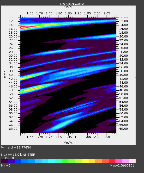
| Estimated Moho Depth: |
15.0 km |
| Estimated Crust Vp/Vs: |
1.60 |
| Assumed Crust Vp: |
6.306 km/s |
| Estimated Crust Vs: |
3.941 km/s |
| Estimated Crust Poisson's Ratio: |
0.18 |
|
| Radial Match: |
89.77654 % |
| Radial Bump: |
317 |
| Transverse Match: |
60.349133 % |
| Transverse Bump: |
400 |
| SOD ConfigId: |
7422571 |
| Insert Time: |
2019-04-22 09:27:07.377 +0000 |
| GWidth: |
2.5 |
| Max Bumps: |
400 |
| Tol: |
0.001 |
|

Signal To Noise
| Channel | StoN | STA | LTA |
| YT:BENN: :BHZ:20160419T05:31:59.675012Z | 7.732908 | 1.0556405E-6 | 1.3651274E-7 |
| YT:BENN: :BHN:20160419T05:31:59.675012Z | 2.217874 | 4.3508027E-7 | 1.9616996E-7 |
| YT:BENN: :BHE:20160419T05:31:59.675012Z | 2.2294385 | 5.609717E-7 | 2.5162018E-7 |
| Arrivals |
| Ps | 1.5 SECOND |
| PpPs | 5.7 SECOND |
| PsPs/PpSs | 7.2 SECOND |


