You are here: Home > Network List > YT07 - POLENET Stations List
> Station CLRK CLRK > Earthquake Result Viewer
CLRK CLRK - Earthquake Result Viewer
| Earthquake location: |
South Sandwich Islands Region |
| Earthquake latitude/longitude: |
-55.6/-27.2 |
| Earthquake time(UTC): |
2016/04/19 (110) 05:25:39 GMT |
| Earthquake Depth: |
11 km |
| Earthquake Magnitude: |
5.9 MB |
| Earthquake Catalog/Contributor: |
NEIC PDE/NEIC COMCAT |
|
| Network: |
YT POLENET |
| Station: |
CLRK CLRK |
| Lat/Lon: |
77.32 S/141.85 W |
| Elevation: |
1043 m |
|
| Distance: |
41.3 deg |
| Az: |
197.705 deg |
| Baz: |
128.647 deg |
| Ray Param: |
0.07386681 |
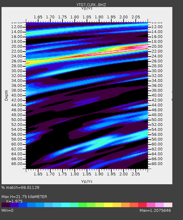
| Estimated Moho Depth: |
21.75 km |
| Estimated Crust Vp/Vs: |
1.98 |
| Assumed Crust Vp: |
6.182 km/s |
| Estimated Crust Vs: |
3.13 km/s |
| Estimated Crust Poisson's Ratio: |
0.33 |
|
| Radial Match: |
86.81129 % |
| Radial Bump: |
400 |
| Transverse Match: |
57.684685 % |
| Transverse Bump: |
400 |
| SOD ConfigId: |
7422571 |
| Insert Time: |
2019-04-22 09:27:07.481 +0000 |
| GWidth: |
2.5 |
| Max Bumps: |
400 |
| Tol: |
0.001 |
|

Signal To Noise
| Channel | StoN | STA | LTA |
| YT:CLRK: :BHZ:20160419T05:32:53.325006Z | 3.233627 | 8.9156464E-7 | 2.757166E-7 |
| YT:CLRK: :BHN:20160419T05:32:53.325006Z | 1.5719713 | 4.3605095E-7 | 2.773912E-7 |
| YT:CLRK: :BHE:20160419T05:32:53.325006Z | 3.59415 | 5.966357E-7 | 1.6600188E-7 |
| Arrivals |
| Ps | 3.6 SECOND |
| PpPs | 9.9 SECOND |
| PsPs/PpSs | 14 SECOND |


