You are here: Home > Network List > YT07 - POLENET Stations List
> Station MA07 Polenet mini-array MA07 > Earthquake Result Viewer
MA07 Polenet mini-array MA07 - Earthquake Result Viewer
| Earthquake location: |
South Sandwich Islands Region |
| Earthquake latitude/longitude: |
-55.6/-27.2 |
| Earthquake time(UTC): |
2016/04/19 (110) 05:25:39 GMT |
| Earthquake Depth: |
11 km |
| Earthquake Magnitude: |
5.9 MB |
| Earthquake Catalog/Contributor: |
NEIC PDE/NEIC COMCAT |
|
| Network: |
YT POLENET |
| Station: |
MA07 Polenet mini-array MA07 |
| Lat/Lon: |
78.25 S/93.50 W |
| Elevation: |
1648 m |
|
| Distance: |
31.5 deg |
| Az: |
201.063 deg |
| Baz: |
83.995 deg |
| Ray Param: |
0.079059646 |
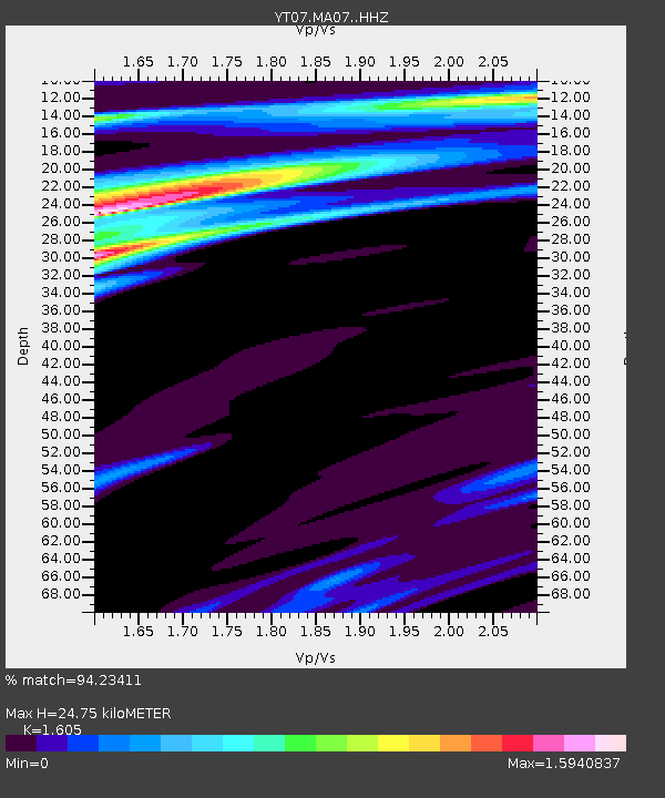
| Estimated Moho Depth: |
24.75 km |
| Estimated Crust Vp/Vs: |
1.61 |
| Assumed Crust Vp: |
6.095 km/s |
| Estimated Crust Vs: |
3.798 km/s |
| Estimated Crust Poisson's Ratio: |
0.18 |
|
| Radial Match: |
94.23411 % |
| Radial Bump: |
278 |
| Transverse Match: |
58.371433 % |
| Transverse Bump: |
400 |
| SOD ConfigId: |
7422571 |
| Insert Time: |
2019-04-22 09:27:16.433 +0000 |
| GWidth: |
2.5 |
| Max Bumps: |
400 |
| Tol: |
0.001 |
|

Signal To Noise
| Channel | StoN | STA | LTA |
| YT:MA07: :HHZ:20160419T05:31:29.499994Z | 7.963745 | 1.7712231E-6 | 2.2241082E-7 |
| YT:MA07: :HHN:20160419T05:31:29.499994Z | 0.7472038 | 1.6757626E-7 | 2.2427113E-7 |
| YT:MA07: :HHE:20160419T05:31:29.499994Z | 4.0197387 | 1.0007387E-6 | 2.4895618E-7 |
| Arrivals |
| Ps | 2.7 SECOND |
| PpPs | 9.8 SECOND |
| PsPs/PpSs | 12 SECOND |


