You are here: Home > Network List > CN - Canadian National Seismograph Network Stations List
> Station INK INUVIK, NT > Earthquake Result Viewer
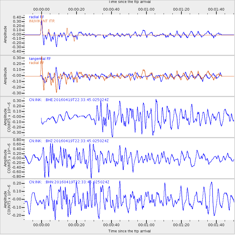
INK INUVIK, NT - Earthquake Result Viewer
*The percent match for this event was below the threshold and hence no stack was calculated.
| Earthquake location: |
Near Coast Of Ecuador |
| Earthquake latitude/longitude: |
0.6/-80.1 |
| Earthquake time(UTC): |
2016/04/19 (110) 22:22:26 GMT |
| Earthquake Depth: |
15 km |
| Earthquake Magnitude: |
5.5 MB |
| Earthquake Catalog/Contributor: |
NEIC PDE/NEIC ALERT |
|
| Network: |
CN Canadian National Seismograph Network |
| Station: |
INK INUVIK, NT |
| Lat/Lon: |
68.31 N/133.53 W |
| Elevation: |
44 m |
|
| Distance: |
76.7 deg |
| Az: |
342.121 deg |
| Baz: |
124.34 deg |
| Ray Param: |
$rayparam |
*The percent match for this event was below the threshold and hence was not used in the summary stack. |
|
| Radial Match: |
69.94466 % |
| Radial Bump: |
400 |
| Transverse Match: |
66.57889 % |
| Transverse Bump: |
400 |
| SOD ConfigId: |
7422571 |
| Insert Time: |
2019-04-22 09:30:42.031 +0000 |
| GWidth: |
2.5 |
| Max Bumps: |
400 |
| Tol: |
0.001 |
|
Signal To Noise
| Channel | StoN | STA | LTA |
| CN:INK: :BHZ:20160419T22:33:45.025024Z | 3.000188 | 3.6582725E-7 | 1.2193476E-7 |
| CN:INK: :BHN:20160419T22:33:45.025024Z | 0.7487464 | 5.7139406E-8 | 7.6313434E-8 |
| CN:INK: :BHE:20160419T22:33:45.025024Z | 2.3822517 | 1.2347073E-7 | 5.182942E-8 |
| Arrivals |
| Ps | |
| PpPs | |
| PsPs/PpSs | |


