You are here: Home > Network List > US - United States National Seismic Network Stations List
> Station JFWS Jewell Farm, Wisconsin, USA > Earthquake Result Viewer
JFWS Jewell Farm, Wisconsin, USA - Earthquake Result Viewer

| Earthquake location: |
Jujuy Province, Argentina |
| Earthquake latitude/longitude: |
-23.5/-66.5 |
| Earthquake time(UTC): |
2000/05/12 (133) 18:43:18 GMT |
| Earthquake Depth: |
225 km |
| Earthquake Magnitude: |
6.2 MB, 7.2 MW, 7.1 MW |
| Earthquake Catalog/Contributor: |
WHDF/NEIC |
|
| Network: |
US United States National Seismic Network |
| Station: |
JFWS Jewell Farm, Wisconsin, USA |
| Lat/Lon: |
42.91 N/90.25 W |
| Elevation: |
335 m |
|
| Distance: |
69.7 deg |
| Az: |
341.573 deg |
| Baz: |
156.743 deg |
| Ray Param: |
0.054843068 |
| Estimated Moho Depth: |
33.75 km |
| Estimated Crust Vp/Vs: |
1.99 |
| Assumed Crust Vp: |
6.53 km/s |
| Estimated Crust Vs: |
3.282 km/s |
| Estimated Crust Poisson's Ratio: |
0.33 |
|
| Radial Match: |
97.47778 % |
| Radial Bump: |
395 |
| Transverse Match: |
90.31848 % |
| Transverse Bump: |
400 |
| SOD ConfigId: |
110165 |
| Insert Time: |
2010-03-05 01:53:22.467 +0000 |
| GWidth: |
2.5 |
| Max Bumps: |
400 |
| Tol: |
0.001 |
|
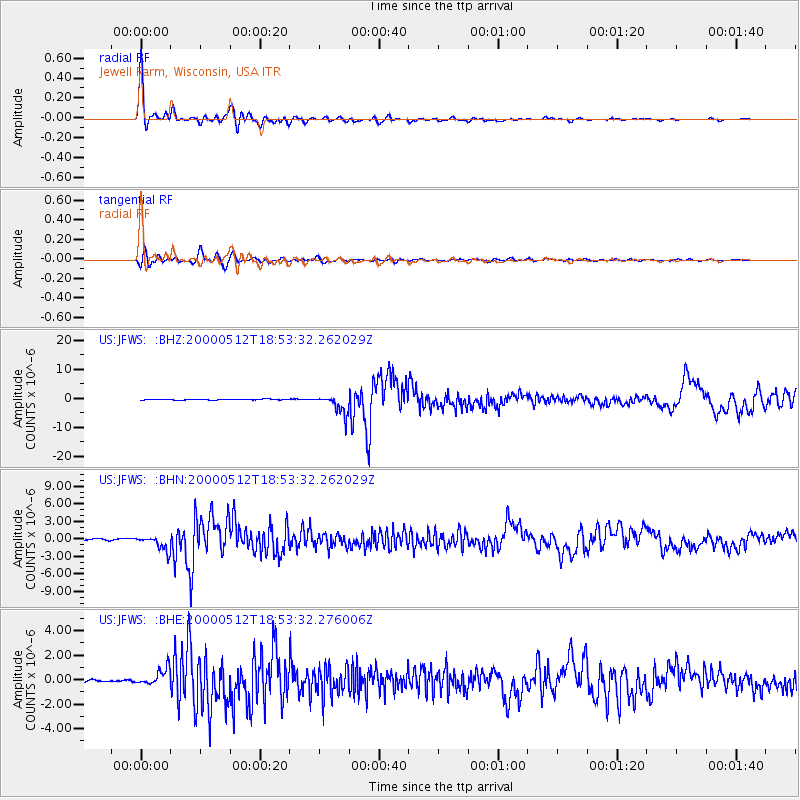
Signal To Noise
| Channel | StoN | STA | LTA |
| US:JFWS: :BHN:20000512T18:53:32.262029Z | 9.836938 | 1.2890173E-6 | 1.3103848E-7 |
| US:JFWS: :BHE:20000512T18:53:32.276006Z | 6.293871 | 7.0762457E-7 | 1.1243074E-7 |
| US:JFWS: :BHZ:20000512T18:53:32.262029Z | 21.918917 | 3.2873277E-6 | 1.4997674E-7 |
| Arrivals |
| Ps | 5.3 SECOND |
| PpPs | 15 SECOND |
| PsPs/PpSs | 20 SECOND |


