You are here: Home > Network List > US - United States National Seismic Network Stations List
> Station JFWS Jewell Farm, Wisconsin, USA > Earthquake Result Viewer
JFWS Jewell Farm, Wisconsin, USA - Earthquake Result Viewer

| Earthquake location: |
Samoa Islands Region |
| Earthquake latitude/longitude: |
-14.9/-173.3 |
| Earthquake time(UTC): |
2001/06/16 (167) 02:13:38 GMT |
| Earthquake Depth: |
10 km |
| Earthquake Magnitude: |
5.6 MB, 5.8 MS, 6.0 MW, 6.0 MW |
| Earthquake Catalog/Contributor: |
WHDF/NEIC |
|
| Network: |
US United States National Seismic Network |
| Station: |
JFWS Jewell Farm, Wisconsin, USA |
| Lat/Lon: |
42.91 N/90.25 W |
| Elevation: |
335 m |
|
| Distance: |
95.0 deg |
| Az: |
47.066 deg |
| Baz: |
254.483 deg |
| Ray Param: |
0.040888976 |
| Estimated Moho Depth: |
10.0 km |
| Estimated Crust Vp/Vs: |
1.60 |
| Assumed Crust Vp: |
6.53 km/s |
| Estimated Crust Vs: |
4.082 km/s |
| Estimated Crust Poisson's Ratio: |
0.18 |
|
| Radial Match: |
99.979195 % |
| Radial Bump: |
2 |
| Transverse Match: |
99.98284 % |
| Transverse Bump: |
3 |
| SOD ConfigId: |
110165 |
| Insert Time: |
2010-03-05 01:53:25.819 +0000 |
| GWidth: |
2.5 |
| Max Bumps: |
400 |
| Tol: |
0.001 |
|
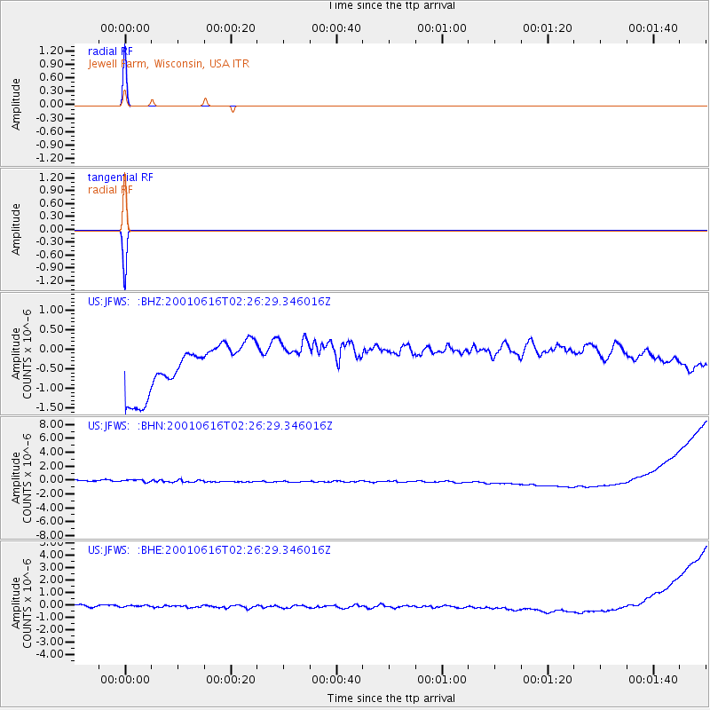
Signal To Noise
| Channel | StoN | STA | LTA |
| US:JFWS: :BHN:20010616T02:26:29.346016Z | 0.94163305 | 6.9036514E-7 | 7.331573E-7 |
| US:JFWS: :BHE:20010616T02:26:29.346016Z | 0.89887774 | 3.5993142E-7 | 4.0042312E-7 |
| US:JFWS: :BHZ:20010616T02:26:29.346016Z | 0.8986301 | 5.3542516E-7 | 5.9582374E-7 |
| Arrivals |
| Ps | 0.9 SECOND |
| PpPs | 3.9 SECOND |
| PsPs/PpSs | 4.8 SECOND |


