You are here: Home > Network List > LD - Lamont-Doherty Cooperative Seismographic Network Stations List
> Station MVL Millersville University, PA > Earthquake Result Viewer
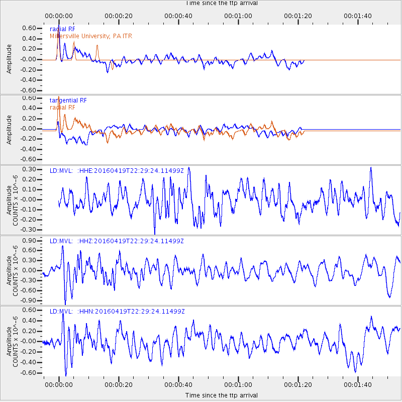
MVL Millersville University, PA - Earthquake Result Viewer
*The percent match for this event was below the threshold and hence no stack was calculated.
| Earthquake location: |
Near Coast Of Ecuador |
| Earthquake latitude/longitude: |
0.6/-80.1 |
| Earthquake time(UTC): |
2016/04/19 (110) 22:22:26 GMT |
| Earthquake Depth: |
15 km |
| Earthquake Magnitude: |
5.5 MB |
| Earthquake Catalog/Contributor: |
NEIC PDE/NEIC ALERT |
|
| Network: |
LD Lamont-Doherty Cooperative Seismographic Network |
| Station: |
MVL Millersville University, PA |
| Lat/Lon: |
40.00 N/76.35 W |
| Elevation: |
91 m |
|
| Distance: |
39.4 deg |
| Az: |
4.486 deg |
| Baz: |
185.844 deg |
| Ray Param: |
$rayparam |
*The percent match for this event was below the threshold and hence was not used in the summary stack. |
|
| Radial Match: |
63.030727 % |
| Radial Bump: |
400 |
| Transverse Match: |
46.031963 % |
| Transverse Bump: |
400 |
| SOD ConfigId: |
7422571 |
| Insert Time: |
2019-04-22 09:32:36.834 +0000 |
| GWidth: |
2.5 |
| Max Bumps: |
400 |
| Tol: |
0.001 |
|
Signal To Noise
| Channel | StoN | STA | LTA |
| LD:MVL: :HHZ:20160419T22:29:24.11499Z | 5.713246 | 4.8021695E-7 | 8.405327E-8 |
| LD:MVL: :HHN:20160419T22:29:24.11499Z | 3.79958 | 3.0714267E-7 | 8.083595E-8 |
| LD:MVL: :HHE:20160419T22:29:24.11499Z | 1.4009151 | 1.2218918E-7 | 8.722097E-8 |
| Arrivals |
| Ps | |
| PpPs | |
| PsPs/PpSs | |


