You are here: Home > Network List > US - United States National Seismic Network Stations List
> Station HLID Hailey, Idaho, USA > Earthquake Result Viewer
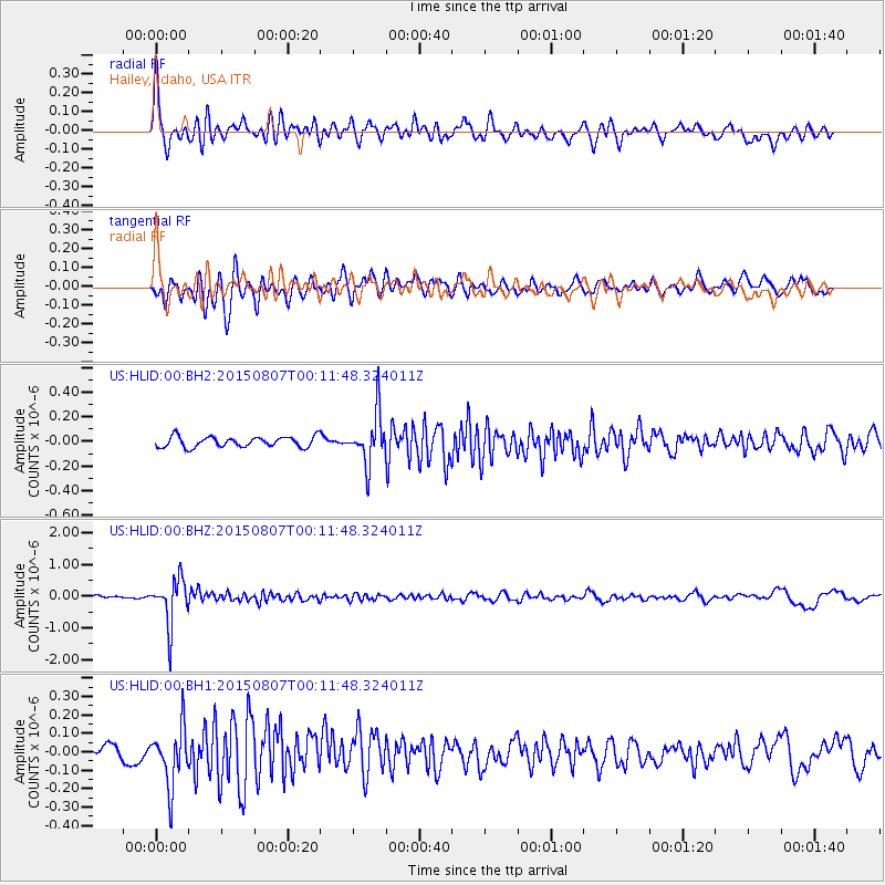
HLID Hailey, Idaho, USA - Earthquake Result Viewer
*The percent match for this event was below the threshold and hence no stack was calculated.
| Earthquake location: |
South Of Fiji Islands |
| Earthquake latitude/longitude: |
-26.5/-178.3 |
| Earthquake time(UTC): |
2015/08/06 (218) 23:59:45 GMT |
| Earthquake Depth: |
264 km |
| Earthquake Magnitude: |
5.9 MB |
| Earthquake Catalog/Contributor: |
NEIC PDE/NEIC ALERT |
|
| Network: |
US United States National Seismic Network |
| Station: |
HLID Hailey, Idaho, USA |
| Lat/Lon: |
43.56 N/114.41 W |
| Elevation: |
1772 m |
|
| Distance: |
91.0 deg |
| Az: |
40.755 deg |
| Baz: |
233.604 deg |
| Ray Param: |
$rayparam |
*The percent match for this event was below the threshold and hence was not used in the summary stack. |
|
| Radial Match: |
74.89513 % |
| Radial Bump: |
400 |
| Transverse Match: |
74.339554 % |
| Transverse Bump: |
400 |
| SOD ConfigId: |
1085051 |
| Insert Time: |
2015-08-21 00:21:34.871 +0000 |
| GWidth: |
2.5 |
| Max Bumps: |
400 |
| Tol: |
0.001 |
|
Signal To Noise
| Channel | StoN | STA | LTA |
| US:HLID:00:BHZ:20150807T00:11:48.324011Z | 15.815635 | 7.2130393E-7 | 4.5607017E-8 |
| US:HLID:00:BH1:20150807T00:11:48.324011Z | 3.1115892 | 1.5824462E-7 | 5.0856524E-8 |
| US:HLID:00:BH2:20150807T00:11:48.324011Z | 4.8255653 | 2.0497623E-7 | 4.2477147E-8 |
| Arrivals |
| Ps | |
| PpPs | |
| PsPs/PpSs | |


