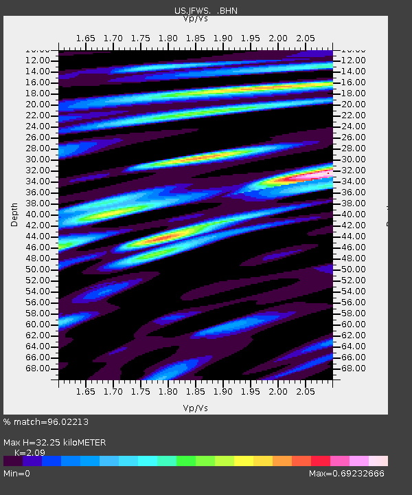
JFWS Jewell Farm, Wisconsin, USA - Earthquake Result Viewer

Earthquake location: Catamarca Province, Argentina
Earthquake latitude/longitude: -28.9/-66.8
Earthquake time(UTC): 2002/05/28 (148) 04:04:22 GMT
Earthquake Depth: 22 km
Earthquake Magnitude: 6.0 MB, 5.7 MS, 6.0 MW, 5.9 MW
Earthquake Catalog/Contributor: WHDF/NEIC
Network: US United States National Seismic Network
Station: JFWS Jewell Farm, Wisconsin, USA
Lat/Lon: 42.91 N/90.25 W
Elevation: 335 m
Distance: 74.7 deg
Az: 342.354 deg
Baz: 158.797 deg
Ray Param: 0.05214511
Estimated Moho Depth: 32.25 km
Estimated Crust Vp/Vs: 2.09
Assumed Crust Vp: 6.53 km/s
Estimated Crust Vs: 3.125 km/s
Estimated Crust Poisson's Ratio: 0.35
Radial Match: 96.02213 %
Radial Bump: 400
Transverse Match: 89.78166 %
Transverse Bump: 400
SOD ConfigId: 110177
Insert Time: 2010-03-05 01:53:53.179 +0000
GWidth: 2.5
Max Bumps: 400
Tol: 0.001

Signal To Noise

ChannelStoNSTALTA
US:JFWS: :BHN:20020528T04:15:29.037019Z6.7628136.521048E-79.642508E-8
US:JFWS: :BHE:20020528T04:15:29.037019Z8.8613483.456999E-73.9012114E-8
US:JFWS: :BHZ:20020528T04:15:29.037019Z18.248181.6582622E-69.087275E-8
Arrivals
Ps5.5 SECOND
PpPs15 SECOND
PsPs/PpSs20 SECOND