You are here: Home > Network List > US - United States National Seismic Network Stations List
> Station JFWS Jewell Farm, Wisconsin, USA > Earthquake Result Viewer
JFWS Jewell Farm, Wisconsin, USA - Earthquake Result Viewer
| Earthquake location: |
Western Brazil |
| Earthquake latitude/longitude: |
-8.3/-71.7 |
| Earthquake time(UTC): |
2002/10/12 (285) 20:09:11 GMT |
| Earthquake Depth: |
534 km |
| Earthquake Magnitude: |
6.5 MB, 6.9 MW, 6.9 MW |
| Earthquake Catalog/Contributor: |
WHDF/NEIC |
|
| Network: |
US United States National Seismic Network |
| Station: |
JFWS Jewell Farm, Wisconsin, USA |
| Lat/Lon: |
42.91 N/90.25 W |
| Elevation: |
335 m |
|
| Distance: |
53.7 deg |
| Az: |
343.175 deg |
| Baz: |
157.05 deg |
| Ray Param: |
0.06365371 |
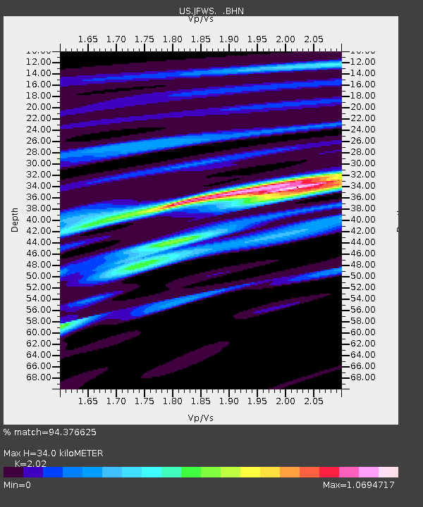
| Estimated Moho Depth: |
34.0 km |
| Estimated Crust Vp/Vs: |
2.02 |
| Assumed Crust Vp: |
6.53 km/s |
| Estimated Crust Vs: |
3.233 km/s |
| Estimated Crust Poisson's Ratio: |
0.34 |
|
| Radial Match: |
94.376625 % |
| Radial Bump: |
400 |
| Transverse Match: |
84.46006 % |
| Transverse Bump: |
400 |
| SOD ConfigId: |
110177 |
| Insert Time: |
2010-03-05 01:54:04.862 +0000 |
| GWidth: |
2.5 |
| Max Bumps: |
400 |
| Tol: |
0.001 |
|

Signal To Noise
| Channel | StoN | STA | LTA |
| US:JFWS: :BHN:20021012T20:17:12.41401Z | 11.898814 | 3.7113641E-6 | 3.119104E-7 |
| US:JFWS: :BHE:20021012T20:17:12.41401Z | 4.023113 | 1.6523189E-6 | 4.107066E-7 |
| US:JFWS: :BHZ:20021012T20:17:12.41401Z | 42.219944 | 7.706633E-6 | 1.8253537E-7 |
| Arrivals |
| Ps | 5.6 SECOND |
| PpPs | 15 SECOND |
| PsPs/PpSs | 21 SECOND |


