You are here: Home > Network List > TA - USArray Transportable Network (new EarthScope stations) Stations List
> Station J26L Joseph Creek, AK, USA > Earthquake Result Viewer
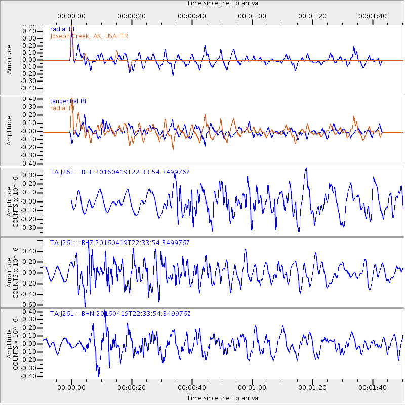
J26L Joseph Creek, AK, USA - Earthquake Result Viewer
*The percent match for this event was below the threshold and hence no stack was calculated.
| Earthquake location: |
Near Coast Of Ecuador |
| Earthquake latitude/longitude: |
0.6/-80.1 |
| Earthquake time(UTC): |
2016/04/19 (110) 22:22:26 GMT |
| Earthquake Depth: |
15 km |
| Earthquake Magnitude: |
5.5 MB |
| Earthquake Catalog/Contributor: |
NEIC PDE/NEIC ALERT |
|
| Network: |
TA USArray Transportable Network (new EarthScope stations) |
| Station: |
J26L Joseph Creek, AK, USA |
| Lat/Lon: |
64.50 N/143.56 W |
| Elevation: |
1144 m |
|
| Distance: |
78.4 deg |
| Az: |
336.7 deg |
| Baz: |
113.97 deg |
| Ray Param: |
$rayparam |
*The percent match for this event was below the threshold and hence was not used in the summary stack. |
|
| Radial Match: |
60.94074 % |
| Radial Bump: |
400 |
| Transverse Match: |
50.159496 % |
| Transverse Bump: |
400 |
| SOD ConfigId: |
7422571 |
| Insert Time: |
2019-04-22 09:36:22.567 +0000 |
| GWidth: |
2.5 |
| Max Bumps: |
400 |
| Tol: |
0.001 |
|
Signal To Noise
| Channel | StoN | STA | LTA |
| TA:J26L: :BHZ:20160419T22:33:54.349976Z | 3.1531143 | 2.7301368E-7 | 8.65854E-8 |
| TA:J26L: :BHN:20160419T22:33:54.349976Z | 0.39500317 | 3.6076674E-8 | 9.133262E-8 |
| TA:J26L: :BHE:20160419T22:33:54.349976Z | 1.8657651 | 1.4238596E-7 | 7.631505E-8 |
| Arrivals |
| Ps | |
| PpPs | |
| PsPs/PpSs | |


