You are here: Home > Network List > CI - Caltech Regional Seismic Network Stations List
> Station DEC Green Verdugo Microwave Site, Sunland, CA, USA > Earthquake Result Viewer
DEC Green Verdugo Microwave Site, Sunland, CA, USA - Earthquake Result Viewer
| Earthquake location: |
Windward Islands |
| Earthquake latitude/longitude: |
15.0/-61.3 |
| Earthquake time(UTC): |
2007/11/29 (333) 19:00:19 GMT |
| Earthquake Depth: |
148 km |
| Earthquake Magnitude: |
6.9 MB, 7.4 MW, 7.4 MW |
| Earthquake Catalog/Contributor: |
WHDF/NEIC |
|
| Network: |
CI Caltech Regional Seismic Network |
| Station: |
DEC Green Verdugo Microwave Site, Sunland, CA, USA |
| Lat/Lon: |
34.25 N/118.33 W |
| Elevation: |
519 m |
|
| Distance: |
54.6 deg |
| Az: |
301.491 deg |
| Baz: |
95.75 deg |
| Ray Param: |
0.0648443 |
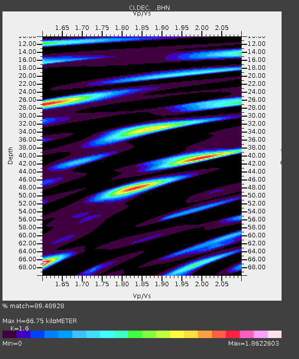
| Estimated Moho Depth: |
66.75 km |
| Estimated Crust Vp/Vs: |
1.60 |
| Assumed Crust Vp: |
6.1 km/s |
| Estimated Crust Vs: |
3.812 km/s |
| Estimated Crust Poisson's Ratio: |
0.18 |
|
| Radial Match: |
89.48928 % |
| Radial Bump: |
400 |
| Transverse Match: |
84.89152 % |
| Transverse Bump: |
400 |
| SOD ConfigId: |
2564 |
| Insert Time: |
2010-02-26 00:17:40.462 +0000 |
| GWidth: |
2.5 |
| Max Bumps: |
400 |
| Tol: |
0.001 |
|
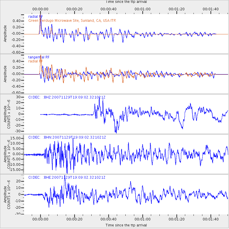
Signal To Noise
| Channel | StoN | STA | LTA |
| CI:DEC: :BHN:20071129T19:09:02.321021Z | 6.606945 | 2.624315E-6 | 3.972055E-7 |
| CI:DEC: :BHE:20071129T19:09:02.321021Z | 8.216566 | 4.4982476E-6 | 5.474608E-7 |
| CI:DEC: :BHZ:20071129T19:09:02.321021Z | 22.2122 | 1.00816815E-5 | 4.5388035E-7 |
| Arrivals |
| Ps | 6.9 SECOND |
| PpPs | 27 SECOND |
| PsPs/PpSs | 34 SECOND |


